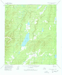
1953 Map of Kantishna River B-3
USGS Topo · Published 1978About this map
Wien Lake dominates the central portion of this 1950s landscape, serving as a primary landmark in a region defined by complex aquatic networks. The map documents an unsurveyed wilderness within the Fairbanks Meridian, where the Zitziana River and John Hansen Creek navigate through extensive wetlands and varying elevations. A single Cabin on the northern shore of the lake suggests the minimal human footprint during this era, likely representing a site for trapping or subsistence activities. Based on aerial photography from 1952, the topography illustrates a transition from low-relief swamps to upland terrain, providing a detailed look at the drainage patterns before any modern development or infrastructure reached this part of the Alaska interior.
Find a feature on this map
5 named features on this map. Tap any name to fly to it.
Don’t see what you’re looking for? This feature index may not catch every label — zoom into the map to look around manually.
Map Details
Editions of this 1953 Kantishna River B-3 Map
3 editions found

Other maps of this area

1948 · Kantishna River
USGS Topo · 1:250,000

1951 · Kantishna River
USGS Topo · 1:250,000

1952 · Kantishna River A-3
USGS Topo · 1:63,360

1952 · Kantishna River
USGS Topo · 1:250,000

1952 · Kantishna River A-2
USGS Topo · 1:63,360

1952 · Kantishna River C-3
USGS Topo · 1:63,360

1952 · Kantishna River C-4
USGS Topo · 1:63,360

1953 · Kantishna River B-2
USGS Topo · 1:63,360

1953 · Kantishna River B-4
USGS Topo · 1:63,360

1953 · Kantishna River A-4
USGS Topo · 1:63,360