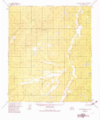
1952 Map of Kantishna River C-4
USGS Topo · Published 1983About this map
The Chitanatala Mountains dominate the western portion of this mid-century Alaskan landscape, giving way to the complex drainage of the Cosna River to the east. Compiled from 1952 aerial photography, the map shows a wilderness area characterized by vast wetlands and seasonal swamps interspersed with prominent peaks. Significant elevations include Lloyd Mountain and survey markers such as VABM Tan and VABM Zitz, which served as critical points for the Bureau of Land Management’s predetermined township and section lines. The presence of Bent Tree Lake near the river valley highlights the region's interior water network. This survey preserves the remote character of the Fairbanks Meridian before modern infrastructure reached this part of the interior, documenting a land of unnamed streams and unsurveyed territories.
Find a feature on this map
6 named features on this map. Tap any name to fly to it.
Don’t see what you’re looking for? This feature index may not catch every label — zoom into the map to look around manually.
Map Details
Editions of this 1952 Kantishna River C-4 Map
3 editions found
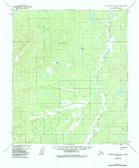
Other maps of this area

1948 · Kantishna River
USGS Topo · 1:250,000

1951 · Kantishna River
USGS Topo · 1:250,000

1952 · Kantishna River C-5
USGS Topo · 1:63,360

1952 · Kantishna River D-5
USGS Topo · 1:63,360

1952 · Kantishna River
USGS Topo · 1:250,000

1952 · Kantishna River B-5
USGS Topo · 1:63,360

1952 · Kantishna River D-3
USGS Topo · 1:63,360

1952 · Kantishna River C-3
USGS Topo · 1:63,360

1952 · Kantishna River C-4
USGS Topo · 1:63,360

1953 · Kantishna River B-4
USGS Topo · 1:63,360