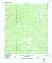
1952 Map of Kantishna River C-4
USGS Topo · Published 1988About this map
The Chitanatala Mountains dominate the western landscape of this interior Alaskan wilderness, rising sharply above the expansive river drainage to the east. This 1952 topographic survey highlights the remote character of the territory before significant modern development, where transportation relied on a solitary Trail and a handful of remote Landing Strips. The Cosna River meanders through the eastern lowlands, creating a complex network of wetlands and small water bodies such as Bent Tree Lake. Survey markers like VABM 2486 Tan and VABM 1441 Zitz serve as primary navigation points in a region defined by high peaks like Lloyd Mountain. The map reveals a landscape where survival and movement were dictated by topography and seasonal water flow.
Find a feature on this map
8 named features on this map. Tap any name to fly to it.
Don’t see what you’re looking for? This feature index may not catch every label — zoom into the map to look around manually.
Map Details
Editions of this 1952 Kantishna River C-4 Map
3 editions found
Other maps of this area

1948 · Kantishna River
USGS Topo · 1:250,000

1951 · Kantishna River
USGS Topo · 1:250,000

1952 · Kantishna River C-5
USGS Topo · 1:63,360

1952 · Kantishna River D-5
USGS Topo · 1:63,360

1952 · Kantishna River
USGS Topo · 1:250,000

1952 · Kantishna River B-5
USGS Topo · 1:63,360

1952 · Kantishna River D-3
USGS Topo · 1:63,360

1952 · Kantishna River C-3
USGS Topo · 1:63,360

1952 · Kantishna River C-4
USGS Topo · 1:63,360

1953 · Kantishna River B-4
USGS Topo · 1:63,360