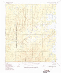
1952 Map of Kantishna River C-6
USGS Topo · Published 1983About this map
Nowitna National Wildlife Refuge encompasses the western portion of this interior Alaskan landscape, which was mapped via photogrammetric methods in the early 1950s. The terrain is characterized by a complex network of wetlands and meandering waterways, notably the Big Mud River which cuts across the central flats and the Chitanana River flowing through the southeastern corner. These rivers create a shifting mosaic of oxbow lakes and marshy basins typical of the Yukon River drainage system. The presence of the Fairbanks Meridian and the West Boundary line highlights the early surveying of these unmarked Bureau of Land Management lands, which were later formally established as federal reservations under the Alaska National Interest Lands Conservation Act. This survey provides a record of the wilderness hydrology before later 20th-century environmental protections were codified.
Find a feature on this map
5 named features on this map. Tap any name to fly to it.
Don’t see what you’re looking for? This feature index may not catch every label — zoom into the map to look around manually.
Map Details
Editions of this 1952 Kantishna River C-6 Map
3 editions found
Other maps of this area

1948 · Kantishna River
USGS Topo · 1:250,000

1951 · Kantishna River
USGS Topo · 1:250,000

1951 · Ruby
USGS Topo · 1:250,000

1952 · Kantishna River C-5
USGS Topo · 1:63,360

1952 · Ruby B-1
USGS Topo · 1:63,360

1952 · Ruby C-1
USGS Topo · 1:63,360

1952 · Kantishna River C-6
USGS Topo · 1:63,360

1952 · Kantishna River D-5
USGS Topo · 1:63,360

1952 · Ruby D-1
USGS Topo · 1:63,360

1952 · Kantishna River
USGS Topo · 1:250,000