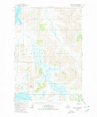
1952 Map of Karluk B-2
USGS Topo · Published 1978About this map
Kodiak Island is defined by a landscape of intricate river systems and coastal lagoons in this mid-century survey of the southwest territory. Much of the terrain lies within the Kodiak National Wildlife Refuge, illustrating a region largely untouched by development or road networks. The western shoreline is shaped by the Shelikof Strait and Grant Lagoon, while the southern reaches meet the Pacific Ocean. This map documents the complex drainage patterns of the Sturgeon River and the meandering Ayakulik River, which dominate the central interior. Notable high points like Anvil Mountain and VABM Ridge 1508 serve as primary landmarks in a territory where the only human imprints recorded are unsurveyed land lines predetermined by the Bureau of Land Management.
Find a feature on this map
14 named features on this map. Tap any name to fly to it.
Don’t see what you’re looking for? This feature index may not catch every label — zoom into the map to look around manually.
Map Details
Editions of this 1952 Karluk B-2 Map
3 editions found
Other maps of this area

1951 · Karluk
USGS Topo · 1:250,000

1952 · Karluk
USGS Topo · 1:250,000

1952 · Karluk C-2
USGS Topo · 1:63,360

1952 · Karluk B-2
USGS Topo · 1:63,360

1952 · Karluk B-1
USGS Topo · 1:63,360

1952 · Karluk C-1
USGS Topo · 1:63,360

1952 · Karluk A-1
USGS Topo · 1:63,360
1952 · Karluk B-3
USGS Topo · 1:63,360

1952 · Karluk A-2
USGS Topo · 1:63,360
1954 · Karluk A-1
USGS Topo · 1:63,360