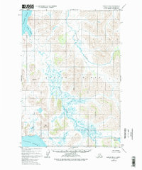
1952 Map of Karluk B-2
USGS Topo · Published 1978About this map
The Kodiak National Wildlife Refuge dominates this 1952 landscape, showcasing a period of pristine coastal wilderness on the western side of Kodiak Island. The map records the complex hydrological system between the Shelikof Strait and the Pacific Ocean, where the Sturgeon River and the meandering Ayakulik River cut through the terrain. Evidence of human presence is minimal, limited to isolated Cabins near Red Lake and the coastal edges of Grant Lagoon.
Find a feature on this map
14 named features on this map. Tap any name to fly to it.
Don’t see what you’re looking for? This feature index may not catch every label — zoom into the map to look around manually.
Map Details
Editions of this 1952 Karluk B-2 Map
3 editions found
Other maps of this area

1951 · Karluk
USGS Topo · 1:250,000

1952 · Karluk
USGS Topo · 1:250,000

1952 · Karluk C-2
USGS Topo · 1:63,360

1952 · Karluk B-2
USGS Topo · 1:63,360

1952 · Karluk B-1
USGS Topo · 1:63,360

1952 · Karluk C-1
USGS Topo · 1:63,360

1952 · Karluk A-1
USGS Topo · 1:63,360
1952 · Karluk B-3
USGS Topo · 1:63,360

1952 · Karluk A-2
USGS Topo · 1:63,360
1954 · Karluk A-1
USGS Topo · 1:63,360