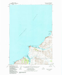
1952 Map of Karluk C-2
USGS Topo · Published 1984About this map
Kodiak Island along the Shelikof Strait reveals a landscape defined by its vital coastal waterways and the enduring settlement of Karluk. This mid-century survey documents the transition from the Karluk River into the Karluk Lagoon, a critical area for local geography and maritime access. To the north, Cape Uyak and Northeast Harbor mark the rugged coastline, while the interior is dominated by the Kodiak National Wildlife Refuge. The map captures essential transport infrastructure of the era, including a Landing Strip, a Seaplane Anchorage, and clustered Fuel Tanks near the village. Traces of smaller habitations such as Aluk and a solitary Cabin appear near the coast, alongside prominent surveying markers like VABM Karluk 2 1420. Further south, the mouth of the Sturgeon River terminates near Sturgeon Head, anchoring the southern reaches of the quadrangle.
Find a feature on this map
21 named features on this map. Tap any name to fly to it.
Don’t see what you’re looking for? This feature index may not catch every label — zoom into the map to look around manually.
Map Details
Editions of this 1952 Karluk C-2 Map
3 editions found
Other maps of this area

1951 · Karluk
USGS Topo · 1:250,000

1952 · Karluk
USGS Topo · 1:250,000

1952 · Karluk C-2
USGS Topo · 1:63,360

1952 · Karluk B-2
USGS Topo · 1:63,360

1952 · Karluk B-1
USGS Topo · 1:63,360

1952 · Karluk C-1
USGS Topo · 1:63,360
1952 · Karluk B-3
USGS Topo · 1:63,360
1954 · Karluk C-1
USGS Topo · 1:63,360
1954 · Karluk B-1
USGS Topo · 1:63,360
1954 · Karluk B-2
USGS Topo · 1:63,360