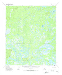
1952 Map of Kateel River A-3
USGS Topo · Published 1974About this map
The Koyukuk River dominates the southwestern corner of this interior Alaska landscape, carving a wide path through a complex network of wetlands and oxbows. Just north of the river's main channel, Natlaratlen Slough winds through the alluvial plain, illustrating the shifting hydrology of the region at the time of the 1952 aerial surveys. The terrain is defined by a dense concentration of thaw lakes and ponds, including named bodies of water like Louis Lake and Bucket Lake in the northeastern quadrant.
Find a feature on this map
7 named features on this map. Tap any name to fly to it.
Don’t see what you’re looking for? This feature index may not catch every label — zoom into the map to look around manually.
Map Details
Editions of this 1952 Kateel River A-3 Map
4 editions found
Other maps of this area

1945 · Nulato
USGS Topo · 1:250,000

1951 · Nulato
USGS Topo · 1:250,000

1951 · Kateel River
USGS Topo · 1:250,000

1952 · Kateel River A-2
USGS Topo · 1:63,360

1952 · Nulato D-3
USGS Topo · 1:63,360

1952 · Kateel River A-4
USGS Topo · 1:63,360

1952 · Nulato D-4
USGS Topo · 1:63,360

1952 · Nulato D-2
USGS Topo · 1:63,360

1952 · Kateel River A-3
USGS Topo · 1:63,360

1952 · Kateel River B-3
USGS Topo · 1:63,360