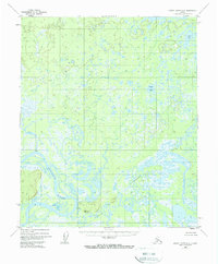
1952 Map of Kateel River A-3
USGS Topo · Published 1974About this map
The meandering Koyukuk River dominates this mid-century landscape of the Alaskan interior, showing a complex network of oxbow lakes and wetlands. The river's powerful hydrological influence is visible through features like the Natuarallen Slough and the Nikolai River, which cut through the low-lying terrain. While much of the quadrangle is defined by unnamed ponds and marshland, specific water bodies such as Louis Lake and Bucket Lake provide rare fixed landmarks in the northern portion of the sheet.
Find a feature on this map
8 named features on this map. Tap any name to fly to it.
Don’t see what you’re looking for? This feature index may not catch every label — zoom into the map to look around manually.
Map Details
Editions of this 1952 Kateel River A-3 Map
4 editions found
Other maps of this area

1945 · Nulato
USGS Topo · 1:250,000

1951 · Nulato
USGS Topo · 1:250,000

1951 · Kateel River
USGS Topo · 1:250,000

1952 · Kateel River A-2
USGS Topo · 1:63,360

1952 · Nulato D-3
USGS Topo · 1:63,360

1952 · Kateel River A-4
USGS Topo · 1:63,360

1952 · Nulato D-4
USGS Topo · 1:63,360

1952 · Nulato D-2
USGS Topo · 1:63,360

1952 · Kateel River A-3
USGS Topo · 1:63,360

1952 · Kateel River B-3
USGS Topo · 1:63,360