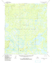
1952 Map of Kateel River A-3
USGS Topo · Published 1992About this map
The Koyukuk National Wildlife Refuge dominates this subarctic landscape, preserving a complex network of wetlands and boreal forest as it appeared in the early 1950s. The meandering Koyukuk River carves through the southwestern quadrant, its shifting path creating a maze of oxbows and secondary channels like the Natlaratlen Slough. This region, characterized by low-lying swamplands and scattered lakes such as Louis Lake and Bucket Lake, reveals the intricate hydrological patterns of the interior.
Find a feature on this map
8 named features on this map. Tap any name to fly to it.
Don’t see what you’re looking for? This feature index may not catch every label — zoom into the map to look around manually.
Map Details
Editions of this 1952 Kateel River A-3 Map
4 editions found
Other maps of this area

1945 · Nulato
USGS Topo · 1:250,000

1951 · Nulato
USGS Topo · 1:250,000

1951 · Kateel River
USGS Topo · 1:250,000

1952 · Kateel River A-2
USGS Topo · 1:63,360

1952 · Nulato D-3
USGS Topo · 1:63,360

1952 · Kateel River A-4
USGS Topo · 1:63,360

1952 · Nulato D-4
USGS Topo · 1:63,360

1952 · Nulato D-2
USGS Topo · 1:63,360

1952 · Kateel River A-3
USGS Topo · 1:63,360

1952 · Kateel River B-3
USGS Topo · 1:63,360