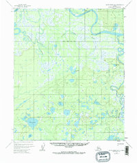
1952 Map of Kateel River B-2
USGS Topo · Published 1972About this map
The Koyukuk River winds through this interior landscape, defining a complex network of wetlands and migratory waterways north of the Kateel River Base Line. Captured via aerial photography in the early 1950s, the terrain is characterized by an intricate system of sloughs and lakes, including the descriptively named Coffee Can Lake and Teethoano Lake. These water bodies are connected by seasonal channels like Kozakakat Slough and Tolishden Slough, which illustrate the dynamic nature of the river's floodplain.
Find a feature on this map
15 named features on this map. Tap any name to fly to it.
Don’t see what you’re looking for? This feature index may not catch every label — zoom into the map to look around manually.
Map Details
Editions of this 1952 Kateel River B-2 Map
3 editions found
Other maps of this area

1951 · Kateel River
USGS Topo · 1:250,000

1952 · Kateel River A-2
USGS Topo · 1:63,360

1952 · Kateel River A-1
USGS Topo · 1:63,360

1952 · Kateel River A-3
USGS Topo · 1:63,360

1952 · Kateel River B-1
USGS Topo · 1:63,360

1952 · Kateel River B-3
USGS Topo · 1:63,360

1952 · Kateel River B-2
USGS Topo · 1:63,360

1954 · Kateel River C-2
USGS Topo · 1:63,360

1954 · Kateel River C-1
USGS Topo · 1:63,360

1954 · Kateel River C-3
USGS Topo · 1:63,360