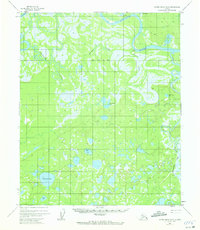
1952 Map of Kateel River B-2
USGS Topo · Published 1972About this map
The Koyukuk River and its intricate drainage network dominate this Alaskan landscape, captured during a 1952 photogrammetric survey. This remote interior region is characterized by a complex system of meandering waterways and seasonal wetlands, where the Dulbi River and Holtnakatna Creek feed into a wilderness punctuated by numerous distinctive lakes. Among these are Coffee Can Lake, Teetheanoe Lake, and Hatseegatloth Lake, names that suggest a history of local navigation and early exploration.
Find a feature on this map
15 named features on this map. Tap any name to fly to it.
Don’t see what you’re looking for? This feature index may not catch every label — zoom into the map to look around manually.
Map Details
Editions of this 1952 Kateel River B-2 Map
3 editions found
Other maps of this area

1951 · Kateel River
USGS Topo · 1:250,000

1952 · Kateel River A-2
USGS Topo · 1:63,360

1952 · Kateel River A-1
USGS Topo · 1:63,360

1952 · Kateel River A-3
USGS Topo · 1:63,360

1952 · Kateel River B-1
USGS Topo · 1:63,360

1952 · Kateel River B-3
USGS Topo · 1:63,360

1952 · Kateel River B-2
USGS Topo · 1:63,360

1954 · Kateel River C-2
USGS Topo · 1:63,360

1954 · Kateel River C-1
USGS Topo · 1:63,360

1954 · Kateel River C-3
USGS Topo · 1:63,360