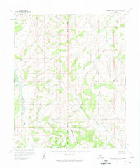
1954 Map of Kateel River C-6
USGS Topo · Published 1974About this map
The Continental Divide traverses this interior Alaskan wilderness, separating the watersheds of the Tagagawik River to the west from the drainage systems to the east. This 1954 survey by the U.S. Geological Survey documents a landscape entirely devoid of permanent settlements or infrastructure, defined instead by the hydrologic network of the Hustlia River and its tributary, the South Fork. The map's vertical control highlights the varied elevation changes through this portion of the Yukon-Koyukuk region, while the Kateel River Principal Meridian serves as the central longitudinal anchor for the survey. These early photogrammetric records provide a foundational view of the terrain before any significant human alteration, including the winding course of Derby creek in the central heights.
Find a feature on this map
7 named features on this map. Tap any name to fly to it.
Don’t see what you’re looking for? This feature index may not catch every label — zoom into the map to look around manually.
Map Details
Editions of this 1954 Kateel River C-6 Map
2 editions found
Other maps of this area

1951 · Candle
USGS Topo · 1:250,000

1951 · Kateel River
USGS Topo · 1:250,000

1954 · Kateel River B-5
USGS Topo · 1:63,360
1954 · Candle D-1
USGS Topo · 1:63,360

1954 · Candle C-1
USGS Topo · 1:63,360

1954 · Kateel River D-6
USGS Topo · 1:63,360

1954 · Candle B-1
USGS Topo · 1:63,360

1954 · Kateel River D-5
USGS Topo · 1:63,360

1954 · Kateel River C-6
USGS Topo · 1:63,360

1955 · Kateel River B-5
USGS Topo · 1:63,360