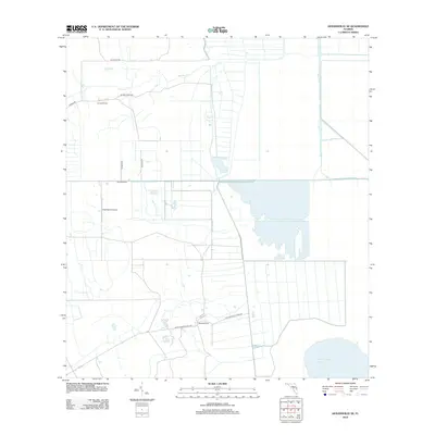
2012 Map of Kenansville SE
USGS Topo · Published 2012About this map
The waters of Blue Cypress Lake define the southeastern corner of this landscape, a region largely shaped by agricultural drainage and ranching in Brevard County. The geometric grid of drainage canals and property boundaries is most evident south of Fellsmere Rd, where extensive field systems and private aviation facilities like RLM Farms Airport indicate a highly managed rural environment. The northern portion of the map is dominated by the course of Sixmile Cr, which meanders through more open terrain past Leonard Ranch. These ranching operations, including Mitchell Ranch further south, are connected by a network of rural routes such as Blue Cypress Ranch Rd and Rollins Blue Cypres Rd. The map illustrates the specialized infrastructure required for large-scale Florida agriculture, from complex water management channels to private airstrips and family-owned ranch holdings.
Find a feature on this map
13 named features on this map. Tap any name to fly to it.
Don’t see what you’re looking for? This feature index may not catch every label — zoom into the map to look around manually.
Map Details
Editions of this 2012 Kenansville SE Map
This is the sole edition of this map. No revisions or reprints were ever made.
Other maps of this area

1953 · Fellsmere SW
USGS Topo · 1:24,000

1953 · Fellsmere NW
USGS Topo · 1:24,000

1953 · Fort Drum NW
USGS Topo · 1:24,000

1953 · Kenansville SW
USGS Topo · 1:24,000

1953 · Kenansville
USGS Topo · 1:24,000

1953 · Fort Drum NE
USGS Topo · 1:24,000

1953 · Kenansville NE
USGS Topo · 1:24,000

1953 · Kenansville SE
USGS Topo · 1:24,000

1953 · Fellsmere 4 NW
USGS Topo · 1:24,000

1956 · Fort Pierce
USGS Topo · 1:250,000