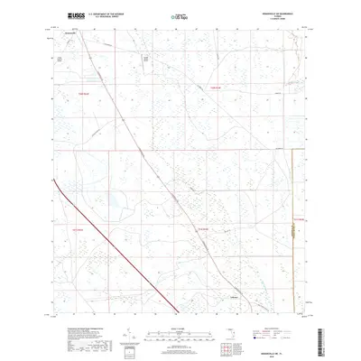
2018 Map of Kenansville SW
USGS Topo · Published 2018About this map
Lokosee and the southern reaches of Kenansville anchor this 2018 survey of the Osceola and Indian River county line. The landscape is defined by vast drainage networks and cattle ranching infrastructure, where S Kenansville Rd serves as the primary corridor through the marshy terrain. The area's agricultural and aviation history is evidenced by the Escape Ranch Airport and Flying S Ranch Airport, while ranching access is provided by routes like Hayman Ranch Rd and Blue Cypress Ranch Rd. Waterways such as Blue Cypress Cr and Sixmile Cr weave through the township sections, illustrating the complex hydrography of this central Florida region. The map preserves the specific road network and section lines that define local property and municipal boundaries in this part of Osceola County.
Find a feature on this map
19 named features on this map. Tap any name to fly to it.
Don’t see what you’re looking for? This feature index may not catch every label — zoom into the map to look around manually.
Map Details
Editions of this 2018 Kenansville SW Map
This is the sole edition of this map. No revisions or reprints were ever made.
Other maps of this area

1953 · Fort Kissimmee NE
USGS Topo · 1:24,000

1953 · Lake Marian SE
USGS Topo · 1:24,000

1953 · Fort Drum NW
USGS Topo · 1:24,000

1953 · Kenansville SW
USGS Topo · 1:24,000

1953 · Kenansville
USGS Topo · 1:24,000

1953 · Fort Drum NE
USGS Topo · 1:24,000

1953 · Kenansville NE
USGS Topo · 1:24,000

1953 · Kenansville SE
USGS Topo · 1:24,000

1953 · Lake Marian NE
USGS Topo · 1:24,000

1956 · Fort Pierce
USGS Topo · 1:250,000