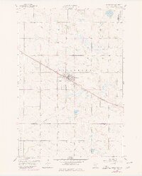
1958 Map of Kerkhoven
USGS Topo · Published 1980About this map
Kerkhoven serves as the primary hub of this west-central Minnesota landscape, situated at the intersection of a local Park and the prominent Great Northern rail line. The surrounding prairie is characterized by a high concentration of wetlands and drainage networks, most notably the winding courses of Shakopee Creek and Mud Creek, alongside the protected National Waterfowl Production Area. These water systems dictate the agricultural layout across the townships of Hayes, Pillsbury, Louriston, and Woods. Genealogists and local historians can find significant landmarks such as Hillside Cem south of the village and West Salem Cem near the eastern boundary. The map also records the utilitarian infrastructure of the era, including several Gravel Pits and a cross-country Pipeline, which reflect the regional economy during the mid-twentieth century before modern land-use revisions.
Find a feature on this map
18 named features on this map. Tap any name to fly to it.
Don’t see what you’re looking for? This feature index may not catch every label — zoom into the map to look around manually.
Map Details
Editions of this 1958 Kerkhoven Map
3 editions found
Other maps of this area

1953 · Saint Cloud
USGS Topo · 1:250,000

1957 · Saint Cloud
USGS Topo · 1:250,000

1958 · Saint Cloud
USGS Topo · 1:250,000

1958 · Murdock
USGS Topo · 1:24,000

1958 · Kerkhoven SE
USGS Topo · 1:24,000

1958 · Kerkhoven
USGS Topo · 1:24,000

1958 · Kerkhoven SW
USGS Topo · 1:24,000

1958 · Raymond
USGS Topo · 1:24,000

1958 · Pennock
USGS Topo · 1:24,000

1967 · Sunburg
USGS Topo · 1:24,000