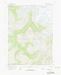
1955 Map of Ketchikan D-2
USGS Topo · Published 1963About this map
Chickamin River carves a deep valley through the glaciated terrain of the Tongass National Forest in this mid-century topographic study. The landscape is defined by the massive Through Glacier in the northeast, which feeds into a network of drainage systems including the South Fork Chickamin River and the winding Barrier Creek. The presence of Walker Lake in the southern portion and Indian Creek in the north highlights the complex hydrology of this undeveloped wilderness. At this time, no roads or trails were recorded in the area, emphasizing its character as a roadless expanse of the Alaska panhandle where movement was dictated entirely by river valleys and glacial passes. This survey represents the topography as it was documented from 1948 aerial photography and 1955 field annotations.
Find a feature on this map
8 named features on this map. Tap any name to fly to it.
Don’t see what you’re looking for? This feature index may not catch every label — zoom into the map to look around manually.
Map Details
Editions of this 1955 Ketchikan D-2 Map
4 editions found
Other maps of this area

1951 · Bradfield Canal
USGS Topo · 1:250,000

1952 · Ketchikan
USGS Topo · 1:250,000

1954 · Bradfield Canal
USGS Topo · 1:250,000

1955 · Ketchikan C-3
USGS Topo · 1:63,360

1955 · Ketchikan D-2
USGS Topo · 1:63,360

1955 · Bradfield canal A-2
USGS Topo · 1:63,360

1955 · Ketchikan C-2
USGS Topo · 1:63,360

1955 · Ketchikan D-3
USGS Topo · 1:63,360

1955 · Bradfield Canal A-1
USGS Topo · 1:63,360

1955 · Ketchikan D-1
USGS Topo · 1:63,360