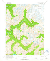
1955 Map of Ketchikan D-2
USGS Topo · Published 1963About this map
Tongass National Forest dominates this mid-century topographic study, which documents a landscape defined by dramatic elevation changes and significant glacial activity. The Through Glacier occupies the northeastern quadrant, serving as a primary source for the complex hydrological network that feeds into the Chickamin River. This river system, including the South Fork Chickamin River, carves through the terrain, joined by tributaries such as Indian Creek and Barrier Creek. To the south, Walker Lake provides a notable basin in this unsurveyed territory. The map reflects a moment in the mid-1950s when the region's land lines were predetermined by the State of Alaska but remained unmarked on the ground, emphasizing the primitive state of transport and settlement in this coastal wilderness near the Davis River.
Find a feature on this map
8 named features on this map. Tap any name to fly to it.
Don’t see what you’re looking for? This feature index may not catch every label — zoom into the map to look around manually.
Map Details
Editions of this 1955 Ketchikan D-2 Map
4 editions found
Other maps of this area

1951 · Bradfield Canal
USGS Topo · 1:250,000

1952 · Ketchikan
USGS Topo · 1:250,000

1954 · Bradfield Canal
USGS Topo · 1:250,000

1955 · Ketchikan C-3
USGS Topo · 1:63,360

1955 · Ketchikan D-2
USGS Topo · 1:63,360

1955 · Bradfield canal A-2
USGS Topo · 1:63,360

1955 · Ketchikan C-2
USGS Topo · 1:63,360

1955 · Ketchikan D-3
USGS Topo · 1:63,360

1955 · Bradfield Canal A-1
USGS Topo · 1:63,360

1955 · Ketchikan D-1
USGS Topo · 1:63,360