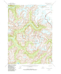
1955 Map of Ketchikan D-2
USGS Topo · Published 1985About this map
Through Glacier dominates the northern reaches of this coastal Alaskan landscape, marking a terrain defined by ice and significant elevation shifts. This 1955 survey illustrates the primitive drainage patterns of the Chickamin River and its South Fork Chickamin River, which carve through the heart of the Tongass National Forest. The map reflects a period before the establishment of modern administrative designations like the Misty Fjords National Monument and Misty Fjords Wilderness, which were later overlaid on these topographic records. Notable water bodies such as Walker Lake and Barrier Creek provide specific points of reference for navigating the steep-walled valleys and glacial outflows characteristic of the Ketchikan quadrangle. This document is a primary record of the natural geography of the region as it existed in the mid-twentieth century.
Find a feature on this map
10 named features on this map. Tap any name to fly to it.
Don’t see what you’re looking for? This feature index may not catch every label — zoom into the map to look around manually.
Map Details
Editions of this 1955 Ketchikan D-2 Map
4 editions found
Other maps of this area

1951 · Bradfield Canal
USGS Topo · 1:250,000

1952 · Ketchikan
USGS Topo · 1:250,000

1954 · Bradfield Canal
USGS Topo · 1:250,000

1955 · Ketchikan C-3
USGS Topo · 1:63,360

1955 · Ketchikan D-2
USGS Topo · 1:63,360

1955 · Bradfield canal A-2
USGS Topo · 1:63,360

1955 · Ketchikan C-2
USGS Topo · 1:63,360

1955 · Ketchikan D-3
USGS Topo · 1:63,360

1955 · Bradfield Canal A-1
USGS Topo · 1:63,360

1955 · Ketchikan D-1
USGS Topo · 1:63,360