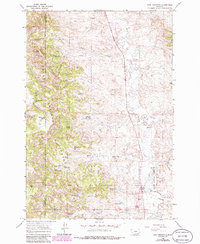
1966 Map of King Mountain
USGS Topo · Published 1986About this map
King Mountain serves as the topographic anchor for this remote section of the Custer National Forest along the border of Rosebud and Powder River counties. The landscape is defined by an intricate network of seasonal drainage systems and essential water infrastructure, vital for ranching in this arid environment. A cluster of water sources such as Paget Reservoir No 1, Chromo Reservoir, and Newell Creek Reservoir are scattered across the terrain, connected by a network of unimproved roads and a Jeep Trail. Many of these features, including Brian Spring No 1 and Drop Tube Reservoir, carry family or descriptive names that provide important clues for local history and genealogy. The meandering paths of Otter Creek and Fifteenmile Creek illustrate the natural erosion patterns through the canyons, while the presence of the Last Chance Reservoir suggests the high stakes of water management in the high plains.
Find a feature on this map
36 named features on this map. Tap any name to fly to it.
Don’t see what you’re looking for? This feature index may not catch every label — zoom into the map to look around manually.
Map Details
Editions of this 1966 King Mountain Map
3 editions found
Other maps of this area

1954 · Hardin
USGS Topo · 1:250,000

1957 · Hardin
USGS Topo · 1:250,000

1958 · Hardin
USGS Topo · 1:250,000

1966 · Goodspeed Butte
USGS Topo · 1:24,000

1966 · Coleman Draw
USGS Topo · 1:24,000

1966 · Ashland
USGS Topo · 1:24,000

1966 · Poker Jim Butte
USGS Topo · 1:24,000

1966 · Fort Howes
USGS Topo · 1:24,000

1966 · King Mountain
USGS Topo · 1:24,000

1966 · Willow Crossing
USGS Topo · 1:24,000