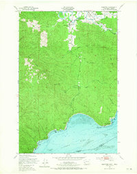
1949 Map of Knappton
USGS Topo · Published 1965About this map
Naselle serves as the primary hub in this coastal river landscape, situated where the Naselle River begins its winding course through the timbered heights of Naselle Ridge. The survey captures a mid-century period of transition, documenting the infrastructure of earlier industry and public health along the shoreline. Of particular interest to local historians is the Quarantine Sta located on the tidal flats near Knappton, and the Old Railroad Grade that traces the valley of the South Fork Naselle River, indicating the historical importance of logging and transport in the region. Educational and community life is anchored at the Naselle-Grays River High Sch and the nearby Peaceful Hill Cem. Along the broad reach of the Columbia River, landmarks like Portuguese Point and the Grays Point Light guided maritime traffic toward the Pacific, past the small settlements of Frankfort and Megler.
Find a feature on this map
34 named features on this map. Tap any name to fly to it.
Don’t see what you’re looking for? This feature index may not catch every label — zoom into the map to look around manually.
Map Details
Editions of this 1949 Knappton Map
5 editions found

Other maps of this area

1919 · Astoria
USGS Topo · 1:62,500

1938 · Fort Columbia
USGS Topo · 1:62,500

1939 · Astoria
USGS Topo · 1:62,500

1940 · Svensen
USGS Topo · 1:62,500

1940 · Brookfield
USGS Topo · 1:62,500

1943 · Fort Columbia
USGS Topo · 1:62,500

1949 · Astoria
USGS Topo · 1:24,000

1949 · Chinook
USGS Topo · 1:24,000

1949 · Upper Naselle River
USGS Topo · 1:24,000

1949 · Oman Ranch
USGS Topo · 1:24,000