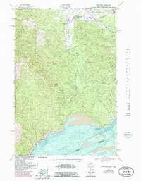
1949 Map of Knappton
USGS Topo · Published 1985About this map
Knappton and the shoreline of the Columbia River anchor this mid-century look at the southern tip of Pacific County, where the tidal estuary meets the steep timbered slopes of Bear River Ridge. The river's influence is central to the area's geography, visible in the bathymetric depths of Hungry Harbor and the navigational significance of Grays Point Light. Inland, the landscape is defined by the winding course of the Naselle River, which supports small communities like Naselle and local educational hubs such as Naselle-Grays River High Sch. Evidence of the region's industrial past is etched into the terrain via the Old Railroad Grade that cuts across the Naselle Ridge. Isolated settlements like Frankfort and the Johnson Ranch appear as quiet outposts between the high ridges and the wide, shifting waters of the Columbia.
Find a feature on this map
31 named features on this map. Tap any name to fly to it.
Don’t see what you’re looking for? This feature index may not catch every label — zoom into the map to look around manually.
Map Details
Editions of this 1949 Knappton Map
5 editions found

Other maps of this area

1919 · Astoria
USGS Topo · 1:62,500

1938 · Fort Columbia
USGS Topo · 1:62,500

1939 · Astoria
USGS Topo · 1:62,500

1940 · Svensen
USGS Topo · 1:62,500

1940 · Brookfield
USGS Topo · 1:62,500

1943 · Fort Columbia
USGS Topo · 1:62,500

1949 · Astoria
USGS Topo · 1:24,000

1949 · Chinook
USGS Topo · 1:24,000

1949 · Upper Naselle River
USGS Topo · 1:24,000

1949 · Oman Ranch
USGS Topo · 1:24,000