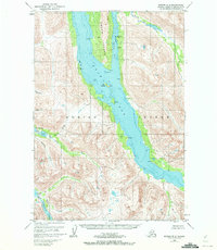
1952 Map of Kodiak B-6
USGS Topo · Published 1972About this map
Amook Island and the surrounding waters of Uyak Bay dominate this 1952 topographic survey, which documents the remote coastal interior of the Kodiak National Wildlife Refuge. The map reveals a landscape defined by deep fjords and salmon-rich waterways, including the North Fork and East Fork of the Thumb River. Evidence of early 20th-century activity appears on the eastern shore of Amook Bay, where a Cem and a Mine (Aband) are located near Camp.
Find a feature on this map
24 named features on this map. Tap any name to fly to it.
Don’t see what you’re looking for? This feature index may not catch every label — zoom into the map to look around manually.
Map Details
Editions of this 1952 Kodiak B-6 Map
3 editions found
Other maps of this area

1951 · Karluk
USGS Topo · 1:250,000

1952 · Kodiak
USGS Topo · 1:250,000

1952 · Karluk
USGS Topo · 1:250,000

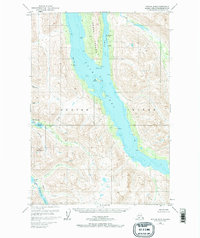
1952 · Kodiak B-6
USGS Topo · 1:63,360

1952 · Karluk B-1
USGS Topo · 1:63,360

1952 · Kodiak C-5
USGS Topo · 1:63,360

1952 · Kodiak B-5
USGS Topo · 1:63,360

1952 · Karluk C-1
USGS Topo · 1:63,360

1952 · Kodiak C-6
USGS Topo · 1:63,360

1952 · Karluk A-1
USGS Topo · 1:63,360