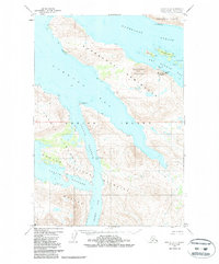
1952 Map of Kodiak D-4
USGS Topo · Published 1987About this map
Port Bailey Cannery serves as a primary industrial landmark on this mid-century survey of the rugged northern coastline of Kodiak Island. Located on the Kupreanof Peninsula near Perenosa Pt, the facility is supported by an adjacent Seaplane Base, illustrating the critical role of maritime and aerial transport in the region's salmon packing economy. The landscape is defined by deep fjords and narrow waterways, including Kupreanof Strait and Uganik Passage, which separate the main island from Raspberry Island and Dry Spruce I.
Find a feature on this map
29 named features on this map. Tap any name to fly to it.
Don’t see what you’re looking for? This feature index may not catch every label — zoom into the map to look around manually.
Map Details
Editions of this 1952 Kodiak D-4 Map
3 editions found

Other maps of this area

1947 · Kodiak D-3
USGS Topo · 1:63,360

1949 · Kodiak D-3
USGS Topo · 1:63,360

1950 · Kodiak D-3
USGS Topo · 1:63,360

1952 · Kodiak
USGS Topo · 1:250,000

1952 · Afognak
USGS Topo · 1:250,000

1952 · Kodiak C-3
USGS Topo · 1:63,360

1952 · Afognak A-4
USGS Topo · 1:63,360

1952 · Kodiak C-4
USGS Topo · 1:63,360

1952 · Kodiak C-5
USGS Topo · 1:63,360

1952 · Kodiak D-5
USGS Topo · 1:63,360