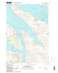
1952 Map of Kodiak D-4
USGS Topo · Published 1987About this map
Industrial maritime activity centers on the Port Bailey Cannery along the northeastern shore of the Kupreanof Peninsula. This 1952 survey, updated with 1980s hydrographic data, captures the intersection of commercial fishing and wilderness within the Kodiak National Wildlife Refuge. The landscape is dominated by deep glacial fjords and narrow waterways like Uganik Passage and Terror Bay, providing protected routes for local vessels.
Find a feature on this map
29 named features on this map. Tap any name to fly to it.
Don’t see what you’re looking for? This feature index may not catch every label — zoom into the map to look around manually.
Map Details
Editions of this 1952 Kodiak D-4 Map
3 editions found

Other maps of this area

1947 · Kodiak D-3
USGS Topo · 1:63,360

1949 · Kodiak D-3
USGS Topo · 1:63,360

1950 · Kodiak D-3
USGS Topo · 1:63,360

1952 · Kodiak
USGS Topo · 1:250,000

1952 · Afognak
USGS Topo · 1:250,000

1952 · Kodiak C-3
USGS Topo · 1:63,360

1952 · Afognak A-4
USGS Topo · 1:63,360

1952 · Kodiak C-4
USGS Topo · 1:63,360

1952 · Kodiak C-5
USGS Topo · 1:63,360

1952 · Kodiak D-5
USGS Topo · 1:63,360