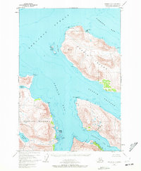
1952 Map of Kodiak D-5
USGS Topo · Published 1972About this map
Uganik Island dominates this mid-century topographic study, separated from the larger landmass of Kodiak Island by the waters of Uganik Passage. The maritime industry of the era is evident at the Village Islands, where a Cannery and Seaplane Base mark a hub of coastal activity. On the shore nearby, a Cemetery provides a genealogical touchpoint for this remote island community.
Find a feature on this map
32 named features on this map. Tap any name to fly to it.
Don’t see what you’re looking for? This feature index may not catch every label — zoom into the map to look around manually.
Map Details
Editions of this 1952 Kodiak D-5 Map
3 editions found
Historical Maps of Kodiak Island Through Time
335 maps found

1947 Kodiak D-3
Kodiak Island Borough, AK

1949 Kodiak A-3
Kodiak Island Borough, AK

1949 Kodiak B-1 and B-2
Kodiak Island Borough, AK

1949 Kodiak B-3
Kodiak Island Borough, AK

1949 Kodiak C-1
Kodiak Island Borough, AK

1949 Kodiak C-2
Kodiak Island Borough, AK

1949 Kodiak D-1
Kodiak Island Borough, AK

1949 Kodiak D-2
Kodiak Island Borough, AK

1949 Kodiak D-3
Kodiak Island Borough, AK

1950 Kodiak A-3
Kodiak Island Borough, AK

1950 Kodiak B-3
Kodiak Island Borough, AK

1950 Kodiak D-3
Kodiak Island Borough, AK

1951 Afognak C-5
Kodiak Island Borough, AK

1951 Afognak C-6
Kodiak Island Borough, AK

1951 Afognak D-1
Kodiak Island Borough, AK

1951 Kaguyak
Kodiak Island Borough, AK

1951 Karluk C-4 and C-5
Kodiak Island Borough, AK

1951 Karluk C-6
Kodiak Island Borough, AK

1951 Karluk D-4
Kodiak Island Borough, AK

1951 Kodiak B-1 and B-2
Kodiak Island Borough, AK

1951 Kodiak C-1
Kodiak Island Borough, AK

1951 Kodiak D-1
Kodiak Island Borough, AK

1951 Kodiak D-2
Kodiak Island Borough, AK

1951 Kodiak D-6
Kodiak Island Borough, AK

1951 Mount Katmai A-1
Kodiak Island Borough, AK

1951 Mount Katmai A-3
Kodiak Island Borough, AK

1951 Mount Katmai B-1
Kodiak Island Borough, AK

1951 Mount Katmai C-1
Kodiak Island Borough, AK

1951 Mt. Katmai A-2
Kodiak Island Borough, AK

1951 Mt. Katmai A-4
Kodiak Island Borough, AK

1951 Mt. Katmai B-2
Kodiak Island Borough, AK

1951 Trinity Islands
Kodiak Island Borough, AK

1951 Ugashik B-1
Kodiak Island Borough, AK

1951 Ugashik B-2
Kodiak Island Borough, AK

1952 Afognak A-0 and B-0
Kodiak Island Borough, AK

1952 Afognak A-1
Kodiak Island Borough, AK

1952 Afognak A-2
Kodiak Island Borough, AK

1952 Afognak A-3
Kodiak Island Borough, AK

1952 Afognak A-4
Kodiak Island Borough, AK

1952 Afognak A-5
Kodiak Island Borough, AK

1952 Afognak B-1
Kodiak Island Borough, AK

1952 Afognak B-2
Kodiak Island Borough, AK

1952 Afognak B-4
Kodiak Island Borough, AK

1952 Afognak C-1 and C-2
Kodiak Island Borough, AK

1952 Afognak C-2 and C-3
Kodiak Island Borough, AK

1952 Afognak
Kodiak Island Borough, AK

1952 Kaguyak D-5
Kodiak Island Borough, AK

1952 Kaguyak D-6
Kodiak Island Borough, AK

1952 Kaguyak
Kodiak Island Borough, AK

1952 Karluk A-1
Kodiak Island Borough, AK

1952 Karluk A-2
Kodiak Island Borough, AK

1952 Karluk B-1
Kodiak Island Borough, AK

1952 Karluk B-2
Kodiak Island Borough, AK

1952 Karluk B-3
Kodiak Island Borough, AK

1952 Karluk C-1
Kodiak Island Borough, AK

1952 Karluk C-2
Kodiak Island Borough, AK

1952 Kodiak A-4
Kodiak Island Borough, AK

1952 Kodiak A-5
Kodiak Island Borough, AK

1952 Kodiak A-6
Kodiak Island Borough, AK

1952 Kodiak B-4
Kodiak Island Borough, AK

1952 Kodiak B-5
Kodiak Island Borough, AK

1952 Kodiak B-6
Kodiak Island Borough, AK

1952 Kodiak C-3
Kodiak Island Borough, AK

1952 Kodiak C-4
Kodiak Island Borough, AK

1952 Kodiak C-5
Kodiak Island Borough, AK

1952 Kodiak C-6
Kodiak Island Borough, AK

1952 Kodiak D-4
Kodiak Island Borough, AK

1952 Kodiak D-5
Kodiak Island Borough, AK

1952 Trinity Islands B-2 and C-2
Kodiak Island Borough, AK

1952 Trinity Islands B-3 and C-3
Kodiak Island Borough, AK

1952 Trinity Islands C-1
Kodiak Island Borough, AK

1952 Trinity Islands D-1
Kodiak Island Borough, AK

1952 Trinity Islands D-2
Kodiak Island Borough, AK

1953 Afognak A-0 and B-0
Kodiak Island Borough, AK

1953 Afognak A-1
Kodiak Island Borough, AK

1953 Afognak A-4
Kodiak Island Borough, AK

1953 Afognak A-5
Kodiak Island Borough, AK

1953 Trinity Islands B-3 and C-3
Kodiak Island Borough, AK

1954 Afognak A-2
Kodiak Island Borough, AK

1954 Afognak A-3
Kodiak Island Borough, AK

1954 Afognak B-1
Kodiak Island Borough, AK

1954 Afognak B-2
Kodiak Island Borough, AK

1954 Afognak B-3
Kodiak Island Borough, AK

1954 Afognak B-4
Kodiak Island Borough, AK

1954 Afognak C-1 and C-2
Kodiak Island Borough, AK

1954 Afognak C-2 and C-3
Kodiak Island Borough, AK

1954 Kaguyak C-6
Kodiak Island Borough, AK

1954 Kaguyak D-5
Kodiak Island Borough, AK

1954 Kaguyak D-6
Kodiak Island Borough, AK

1954 Karluk A-1
Kodiak Island Borough, AK

1954 Karluk A-2
Kodiak Island Borough, AK

1954 Karluk B-1
Kodiak Island Borough, AK

1954 Karluk B-2
Kodiak Island Borough, AK

1954 Karluk B-3
Kodiak Island Borough, AK

1954 Karluk C-1
Kodiak Island Borough, AK

1954 Karluk C-2
Kodiak Island Borough, AK

1954 Kodiak A-4
Kodiak Island Borough, AK

1954 Kodiak A-5
Kodiak Island Borough, AK

1954 Kodiak A-6
Kodiak Island Borough, AK

1954 Kodiak B-4
Kodiak Island Borough, AK

1954 Kodiak B-5
Kodiak Island Borough, AK

1954 Kodiak B-6
Kodiak Island Borough, AK

1954 Kodiak C-3
Kodiak Island Borough, AK

1954 Kodiak C-4
Kodiak Island Borough, AK

1954 Kodiak C-5
Kodiak Island Borough, AK

1954 Kodiak C-6
Kodiak Island Borough, AK

1954 Kodiak D-4
Kodiak Island Borough, AK

1954 Kodiak D-5
Kodiak Island Borough, AK

1954 Kodiak D-6
Kodiak Island Borough, AK

1954 Trinity Islands B-2 and C-2
Kodiak Island Borough, AK

1954 Trinity Islands C-1
Kodiak Island Borough, AK

1954 Trinity Islands D-1
Kodiak Island Borough, AK

1954 Trinity Islands D-2
Kodiak Island Borough, AK

1954 Trinity Islands
Kodiak Island Borough, AK

1963 Sutwik Island A-3
Kodiak Island Borough, AK

1965 Kodiak D-4
Kodiak Island Borough, AK

1971 Karluk C-4 and C-5
Kodiak Island Borough, AK

1987 Kodiak B-1 NW
Kodiak Island Borough, AK

1987 Kodiak B-2 NE
Kodiak Island Borough, AK

1987 Kodiak C-1 NE
Kodiak Island Borough, AK

1987 Kodiak C-1 NW
Kodiak Island Borough, AK

1987 Kodiak C-1 SE
Kodiak Island Borough, AK

1987 Kodiak C-1 SW
Kodiak Island Borough, AK

1987 Kodiak C-2 NE
Kodiak Island Borough, AK

1987 Kodiak C-2 NW
Kodiak Island Borough, AK

1987 Kodiak C-2 SE
Kodiak Island Borough, AK

1987 Kodiak D-1 SW
Kodiak Island Borough, AK

1987 Kodiak D-2 SE
Kodiak Island Borough, AK

1987 Kodiak D-2 SW
Kodiak Island Borough, AK

2019 Afognak C-5 NE
Kodiak Island Borough, AK

2019 Afognak C-5 NW
Kodiak Island Borough, AK

2019 Afognak C-5 SW
Kodiak Island Borough, AK

2019 Afognak C-6 NE
Kodiak Island Borough, AK

2019 Afognak C-6 NW
Kodiak Island Borough, AK

2019 Afognak C-6 SE
Kodiak Island Borough, AK

2019 Afognak C-6 SW
Kodiak Island Borough, AK

2019 Afognak D-4 SW
Kodiak Island Borough, AK

2019 Afognak D-5 SE
Kodiak Island Borough, AK

2019 Afognak D-5 SW
Kodiak Island Borough, AK

2019 Karluk C-4 NW
Kodiak Island Borough, AK

2019 Karluk C-5 NE
Kodiak Island Borough, AK

2019 Karluk C-5 NW
Kodiak Island Borough, AK

2019 Karluk C-6 NE
Kodiak Island Borough, AK

2019 Karluk C-6 SE
Kodiak Island Borough, AK

2019 Karluk C-6 SW
Kodiak Island Borough, AK

2019 Karluk D-4 NE
Kodiak Island Borough, AK

2019 Karluk D-4 NW
Kodiak Island Borough, AK

2019 Karluk D-4 SE
Kodiak Island Borough, AK

2019 Karluk D-4 SW
Kodiak Island Borough, AK

2019 Karluk D-5 SE
Kodiak Island Borough, AK

2021 Afognak A-0 NE
Kodiak Island Borough, AK

2021 Afognak A-0 NW
Kodiak Island Borough, AK

2021 Afognak A-1 NE
Kodiak Island Borough, AK

2021 Afognak A-1 NW
Kodiak Island Borough, AK

2021 Afognak A-1 SW
Kodiak Island Borough, AK

2021 Afognak A-2 NE
Kodiak Island Borough, AK

2021 Afognak A-2 NW
Kodiak Island Borough, AK

2021 Afognak A-2 SE
Kodiak Island Borough, AK

2021 Afognak A-2 SW
Kodiak Island Borough, AK

2021 Afognak A-3 NE
Kodiak Island Borough, AK

2021 Afognak A-3 NW
Kodiak Island Borough, AK

2021 Afognak A-3 SE
Kodiak Island Borough, AK

2021 Afognak A-3 SW
Kodiak Island Borough, AK

2021 Afognak A-4 NE
Kodiak Island Borough, AK

2021 Afognak A-4 NW
Kodiak Island Borough, AK

2021 Afognak A-4 SE
Kodiak Island Borough, AK

2021 Afognak A-4 SW
Kodiak Island Borough, AK

2021 Afognak A-5 SE
Kodiak Island Borough, AK

2021 Afognak B-0 SE
Kodiak Island Borough, AK

2021 Afognak B-0 SW
Kodiak Island Borough, AK

2021 Afognak B-1 NE
Kodiak Island Borough, AK

2021 Afognak B-1 NW
Kodiak Island Borough, AK

2021 Afognak B-1 SE
Kodiak Island Borough, AK

2021 Afognak B-1 SW
Kodiak Island Borough, AK

2021 Afognak B-2 NE
Kodiak Island Borough, AK

2021 Afognak B-2 NW
Kodiak Island Borough, AK

2021 Afognak B-2 SE
Kodiak Island Borough, AK

2021 Afognak B-2 SW
Kodiak Island Borough, AK

2021 Afognak B-3 NE
Kodiak Island Borough, AK

2021 Afognak B-3 NW
Kodiak Island Borough, AK

2021 Afognak B-3 SE
Kodiak Island Borough, AK

2021 Afognak B-3 SW
Kodiak Island Borough, AK

2021 Afognak B-4 SE
Kodiak Island Borough, AK

2021 Afognak C-1 NW
Kodiak Island Borough, AK

2021 Afognak C-1 SE
Kodiak Island Borough, AK

2021 Afognak C-1 SW
Kodiak Island Borough, AK

2021 Afognak C-2 NE
Kodiak Island Borough, AK

2021 Afognak C-2 NW
Kodiak Island Borough, AK

2021 Afognak C-2 SE
Kodiak Island Borough, AK

2021 Afognak C-2 SW
Kodiak Island Borough, AK

2021 Afognak C-3 SE
Kodiak Island Borough, AK

2021 Afognak D-1 NE
Kodiak Island Borough, AK

2021 Afognak D-1 NW
Kodiak Island Borough, AK

2021 Afognak D-1 OE E NW
Kodiak Island Borough, AK

2021 Afognak D-1 OE W NE
Kodiak Island Borough, AK

2021 Chirikof Island D-5 OE E NW
Kodiak Island Borough, AK

2021 Chirikof Island D-5 OE E SW
Kodiak Island Borough, AK

2021 Chirikof Island D-5 SE
Kodiak Island Borough, AK

2021 Kaguyak C-6 NE
Kodiak Island Borough, AK

2021 Kaguyak C-6 NW
Kodiak Island Borough, AK

2021 Kaguyak C-6 OE S NW
Kodiak Island Borough, AK

2021 Kaguyak C-6 SW
Kodiak Island Borough, AK

2021 Kaguyak D-5 NE
Kodiak Island Borough, AK

2021 Kaguyak D-5 NW
Kodiak Island Borough, AK

2021 Kaguyak D-5 SW
Kodiak Island Borough, AK

2021 Kaguyak D-6 NE
Kodiak Island Borough, AK

2021 Kaguyak D-6 NW
Kodiak Island Borough, AK

2021 Kaguyak D-6 SE
Kodiak Island Borough, AK

2021 Kaguyak D-6 SW
Kodiak Island Borough, AK

2021 Karluk A-1 NE
Kodiak Island Borough, AK

2021 Karluk A-1 NW
Kodiak Island Borough, AK

2021 Karluk A-1 SE
Kodiak Island Borough, AK

2021 Karluk A-1 SW
Kodiak Island Borough, AK

2021 Karluk A-2 NE
Kodiak Island Borough, AK

2021 Karluk A-2 NW
Kodiak Island Borough, AK

2021 Karluk A-2 SE
Kodiak Island Borough, AK

2021 Karluk A-2 SW
Kodiak Island Borough, AK

2021 Karluk B-1 NE
Kodiak Island Borough, AK

2021 Karluk B-1 NW
Kodiak Island Borough, AK

2021 Karluk B-1 SE
Kodiak Island Borough, AK

2021 Karluk B-1 SW
Kodiak Island Borough, AK

2021 Karluk B-2 NE
Kodiak Island Borough, AK

2021 Karluk B-2 NW
Kodiak Island Borough, AK

2021 Karluk B-2 SE
Kodiak Island Borough, AK

2021 Karluk B-2 SW
Kodiak Island Borough, AK

2021 Karluk B-3 NE
Kodiak Island Borough, AK

2021 Karluk B-3 SE
Kodiak Island Borough, AK

2021 Karluk C-1 NE
Kodiak Island Borough, AK

2021 Karluk C-1 NW
Kodiak Island Borough, AK

2021 Karluk C-1 SE
Kodiak Island Borough, AK

2021 Karluk C-1 SW
Kodiak Island Borough, AK

2021 Karluk C-2 NE
Kodiak Island Borough, AK

2021 Karluk C-2 SE
Kodiak Island Borough, AK

2021 Karluk C-2 SW
Kodiak Island Borough, AK

2021 Kodiak A-3 NW
Kodiak Island Borough, AK

2021 Kodiak A-3 SW
Kodiak Island Borough, AK

2021 Kodiak A-4 NE
Kodiak Island Borough, AK

2021 Kodiak A-4 NW
Kodiak Island Borough, AK

2021 Kodiak A-4 OE S NE
Kodiak Island Borough, AK

2021 Kodiak A-4 OE S NW
Kodiak Island Borough, AK

2021 Kodiak A-4 SE
Kodiak Island Borough, AK

2021 Kodiak A-4 SW
Kodiak Island Borough, AK

2021 Kodiak A-5 NE
Kodiak Island Borough, AK

2021 Kodiak A-5 NW
Kodiak Island Borough, AK

2021 Kodiak A-5 SE
Kodiak Island Borough, AK

2021 Kodiak A-5 SW
Kodiak Island Borough, AK

2021 Kodiak A-6 NE
Kodiak Island Borough, AK

2021 Kodiak A-6 NW
Kodiak Island Borough, AK

2021 Kodiak A-6 SE
Kodiak Island Borough, AK

2021 Kodiak A-6 SW
Kodiak Island Borough, AK

2021 Kodiak B-1 NW
Kodiak Island Borough, AK

2021 Kodiak B-2 NE
Kodiak Island Borough, AK

2021 Kodiak B-2 NW
Kodiak Island Borough, AK

2021 Kodiak B-2 SW
Kodiak Island Borough, AK

2021 Kodiak B-3 NE
Kodiak Island Borough, AK

2021 Kodiak B-3 NW
Kodiak Island Borough, AK

2021 Kodiak B-3 SE
Kodiak Island Borough, AK

2021 Kodiak B-3 SW
Kodiak Island Borough, AK

2021 Kodiak B-4 NE
Kodiak Island Borough, AK

2021 Kodiak B-4 NW
Kodiak Island Borough, AK

2021 Kodiak B-4 SE
Kodiak Island Borough, AK

2021 Kodiak B-4 SW
Kodiak Island Borough, AK

2021 Kodiak B-5 NE
Kodiak Island Borough, AK

2021 Kodiak B-5 NW
Kodiak Island Borough, AK

2021 Kodiak B-5 SE
Kodiak Island Borough, AK

2021 Kodiak B-5 SW
Kodiak Island Borough, AK

2021 Kodiak B-6 NE
Kodiak Island Borough, AK

2021 Kodiak B-6 NW
Kodiak Island Borough, AK

2021 Kodiak B-6 SE
Kodiak Island Borough, AK

2021 Kodiak B-6 SW
Kodiak Island Borough, AK

2021 Kodiak C-1 NE
Kodiak Island Borough, AK

2021 Kodiak C-1 NW
Kodiak Island Borough, AK

2021 Kodiak C-1 SE
Kodiak Island Borough, AK

2021 Kodiak C-1 SW
Kodiak Island Borough, AK

2021 Kodiak C-2 NE
Kodiak Island Borough, AK

2021 Kodiak C-2 NW
Kodiak Island Borough, AK

2021 Kodiak C-2 SE
Kodiak Island Borough, AK

2021 Kodiak C-2 SW
Kodiak Island Borough, AK

2021 Kodiak C-3 NE
Kodiak Island Borough, AK

2021 Kodiak C-3 NW
Kodiak Island Borough, AK

2021 Kodiak C-3 SE
Kodiak Island Borough, AK

2021 Kodiak C-3 SW
Kodiak Island Borough, AK

2021 Kodiak C-4 NE
Kodiak Island Borough, AK

2021 Kodiak C-4 NW
Kodiak Island Borough, AK

2021 Kodiak C-4 SE
Kodiak Island Borough, AK

2021 Kodiak C-4 SW
Kodiak Island Borough, AK

2021 Kodiak C-5 NE
Kodiak Island Borough, AK

2021 Kodiak C-5 NW
Kodiak Island Borough, AK

2021 Kodiak C-5 SE
Kodiak Island Borough, AK

2021 Kodiak C-5 SW
Kodiak Island Borough, AK

2021 Kodiak C-6 NE
Kodiak Island Borough, AK

2021 Kodiak C-6 NW
Kodiak Island Borough, AK

2021 Kodiak C-6 SE
Kodiak Island Borough, AK

2021 Kodiak C-6 SW
Kodiak Island Borough, AK

2021 Kodiak D-1 NW
Kodiak Island Borough, AK

2021 Kodiak D-1 SW
Kodiak Island Borough, AK

2021 Kodiak D-2 NE
Kodiak Island Borough, AK

2021 Kodiak D-2 NW
Kodiak Island Borough, AK

2021 Kodiak D-2 SE
Kodiak Island Borough, AK

2021 Kodiak D-2 SW
Kodiak Island Borough, AK

2021 Kodiak D-3 NE
Kodiak Island Borough, AK

2021 Kodiak D-3 NW
Kodiak Island Borough, AK

2021 Kodiak D-3 SE
Kodiak Island Borough, AK

2021 Kodiak D-3 SW
Kodiak Island Borough, AK

2021 Kodiak D-4 NE
Kodiak Island Borough, AK

2021 Kodiak D-4 NW
Kodiak Island Borough, AK

2021 Kodiak D-4 SE
Kodiak Island Borough, AK

2021 Kodiak D-4 SW
Kodiak Island Borough, AK

2021 Kodiak D-5 NE
Kodiak Island Borough, AK

2021 Kodiak D-5 NW
Kodiak Island Borough, AK

2021 Kodiak D-5 SE
Kodiak Island Borough, AK

2021 Kodiak D-5 SW
Kodiak Island Borough, AK

2021 Kodiak D-6 NE
Kodiak Island Borough, AK

2021 Kodiak D-6 NW
Kodiak Island Borough, AK

2021 Kodiak D-6 SE
Kodiak Island Borough, AK

2021 Kodiak D-6 SW
Kodiak Island Borough, AK

2021 Mount Katmai A-3 OE S NE
Kodiak Island Borough, AK

2021 Trinity Islands B-2 NE
Kodiak Island Borough, AK

2021 Trinity Islands B-2 NW
Kodiak Island Borough, AK

2021 Trinity Islands B-3 NE
Kodiak Island Borough, AK

2021 Trinity Islands C-1 NE
Kodiak Island Borough, AK

2021 Trinity Islands C-1 OE S NE
Kodiak Island Borough, AK

2021 Trinity Islands C-1 OE S NW
Kodiak Island Borough, AK

2021 Trinity Islands C-1 SE
Kodiak Island Borough, AK

2021 Trinity Islands C-1 SW
Kodiak Island Borough, AK

2021 Trinity Islands C-2 SE
Kodiak Island Borough, AK

2021 Trinity Islands C-2 SW
Kodiak Island Borough, AK

2021 Trinity Islands C-3 SE
Kodiak Island Borough, AK

2021 Trinity Islands C-3 SW
Kodiak Island Borough, AK

2021 Trinity Islands D-1 NE
Kodiak Island Borough, AK

2021 Trinity Islands D-1 NW
Kodiak Island Borough, AK

2021 Trinity Islands D-1 SE
Kodiak Island Borough, AK

2021 Trinity Islands D-1 SW
Kodiak Island Borough, AK

2021 Trinity Islands D-2 NE
Kodiak Island Borough, AK

2021 Trinity Islands D-2 NW
Kodiak Island Borough, AK