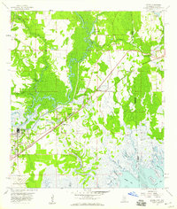
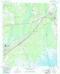
1958 Map of Kreole
USGS Topo · Published 1959About this map
Louisville and Nashville rail lines cut a diagonal path through this coastal landscape, connecting the industrial nodes of Moss Point and Kreole to the broader Gulf corridor. The map reveals a transition from organized settlements like Orange Grove and Orange Lake to the intricate tidal networks of the Grand Bay Swamp. Along the state line between Mississippi and Alabama, the terrain is defined by water, from the winding Escawpa River and Goodes Mill Lake in the north to the brackish reaches of Middle Bay and Grand Bay. Local life is anchored by family-named landmarks and rural institutions, including Franklin Ch, Orange Lake Sch, and the Kivisto Cem. The southern edge is dominated by the Jackson County Airport, highlighting the region's mid-century infrastructure alongside the ancient bayous and islands like Big Island.
Find a feature on this map
39 named features on this map. Tap any name to fly to it.
Don’t see what you’re looking for? This feature index may not catch every label — zoom into the map to look around manually.
Map Details
Editions of this 1958 Kreole Map
5 editions found
Other maps of this area

1921 · Grand Bay
USGS Topo · 1:62,500

1941 · Hurley
USGS Topo · 1:62,500

1941 · Vancleave
USGS Topo · 1:62,500

1943 · Pascagoula
USGS Topo · 1:62,500

1943 · Grand Bay
USGS Topo · 1:62,500

1943 · Hurley
USGS Topo · 1:62,500

1943 · Vancleave
USGS Topo · 1:62,500

1944 · Vancleave
USGS Topo · 1:62,500

1953 · Mobile
USGS Topo · 1:250,000

1955 · Pascagoula
USGS Topo · 1:62,500