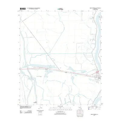
2012 Map of Krotz Springs
USGS Topo · Published 2012About this map
The Atchafalaya River defines the eastern boundary of this Louisiana landscape, where the town of Krotz Springs sits at a critical junction of water and road. This 2012 study documents a complex network of bayous and man-made channels designed for drainage and flood control, including the State Canal and Little State Canal which cut through the low-lying terrain. To the west, the tiny settlement of McClure and the Bayou Courtableau Gas Field indicate the local economic reliance on energy extraction. Genealogists and local historians can locate Midway Cem near the northern edge of the riverbank, while the presence of Majors Airpark near the river reflects modern transportation infrastructure. The map is dominated by a dense hydrologic system where waterways like Big Darbonne Bayou, Two O'clock Bayou, and Threemile Bayou weave between agricultural lands and the Bayou Courtableau Outlet Channel.
Find a feature on this map
55 named features on this map. Tap any name to fly to it.
Don’t see what you’re looking for? This feature index may not catch every label — zoom into the map to look around manually.
Map Details
Editions of this 2012 Krotz Springs Map
This is the sole edition of this map. No revisions or reprints were ever made.
Other maps of this area

1935 · Osca Bayou
USGS Topo · 1:62,500

1939 · Fordoche
USGS Topo · 1:62,500

1940 · Arnaudville
USGS Topo · 1:62,500

1954 · Baton Rouge
USGS Topo · 1:250,000

1955 · Osca Bayou
USGS Topo · 1:62,500

1955 · Fordoche
USGS Topo · 1:62,500

1956 · Baton Rouge
USGS Topo · 1:250,000
1959 · Osca Bayou
USGS Topo · 1:62,500

1959 · Fordoche
USGS Topo · 1:62,500

1959 · Palmetto
USGS Topo · 1:62,500