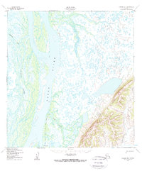
1952 Map of Kwiguk B-4
USGS Topo · Published 1959About this map
Patsys Cabin and other unnamed Cabins stand as isolated markers of human presence along the winding banks of the Anuk River and the massive Yukon River. This 1950s landscape is defined by its intricate aquatic network, where the primary river system gives way to the Tunurokpak Channel and Pektotolik Slough. The seasonal nature of travel in this subarctic environment is evidenced by the Winter Trail, which provides a overland route through the marshy lowlands when the ground is frozen. To the southeast, the topography shifts abruptly from the watery flats toward the rising elevations surrounding the Andreafsky River, illustrating the stark transition between the delta's floodplains and the interior highlands.
Find a feature on this map
8 named features on this map. Tap any name to fly to it.
Don’t see what you’re looking for? This feature index may not catch every label — zoom into the map to look around manually.
Map Details
Editions of this 1952 Kwiguk B-4 Map
3 editions found
Other maps of this area

1952 · Kwiguk
USGS Topo · 1:250,000

1952 · Kwiguk B-3
USGS Topo · 1:63,360

1952 · Kwiguk C-3
USGS Topo · 1:63,360

1952 · Kwiguk A-5
USGS Topo · 1:63,360

1952 · Kwiguk B-5
USGS Topo · 1:63,360

1952 · Kwiguk C-4
USGS Topo · 1:63,360

1952 · Kwiguk A-4
USGS Topo · 1:63,360

1952 · Kwiguk C-5
USGS Topo · 1:63,360

1952 · Kwiguk A-3
USGS Topo · 1:63,360

1952 · Kwiguk B-4
USGS Topo · 1:63,360