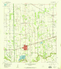
1956 Map of La Feria
USGS Topo · Published 1959About this map
The irrigated landscape of the Lower Rio Grande Valley centers on La Feria in the mid-1950s, where a complex network of canals and elevated ditches supports a thriving agricultural economy. This survey documents the transition between the Hidalgo and Cameron County line, showcasing how the terrain is dominated by water management features like the La Feria Reservoir and the Valley Acres Reservoir. Significant topographic markers include the extensive Tiocano Lake Bed and the winding course of the Arroyo Colorado at the southern edge of the quadrangle.
Find a feature on this map
26 named features on this map. Tap any name to fly to it.
Don’t see what you’re looking for? This feature index may not catch every label — zoom into the map to look around manually.
Map Details
Editions of this 1956 La Feria Map
2 editions found
Other maps of this area

1929 · Harlingen
USGS Topo · 1:24,000

1929 · Santa Rosa
USGS Topo · 1:24,000

1929 · Santa Maria
USGS Topo · 1:24,000

1929 · La Feria
USGS Topo · 1:24,000

1929 · La Paloma
USGS Topo · 1:24,000

1932 · Combes
USGS Topo · 1:31,680

1932 · Harlingen
USGS Topo · 1:31,680

1933 · Santa Rosa
USGS Topo · 1:31,680

1936 · La Feria
USGS Topo · 1:31,680

1936 · Santa Maria
USGS Topo · 1:31,680