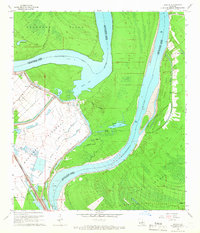
1965 Map of Lacour
USGS Topo · Published 1966About this map
The Mississippi River creates a dynamic landscape of oxbow lakes and alluvial ridges along the border of West Feliciana Parish and Pointe Coupee Parish. Central to this geography is Raccourci Old River, a massive cutoff that isolated Raccourci Island and left behind a series of secondary water bodies like Mondu Lake and Bundy Lake. The small settlement of Lacour sits behind a protective Levee, serving as a focal point for local life alongside Mt Zion Ch and Mount Olive Ch. To the south, the vast Morganza Floodway dominates the terrain, designed to manage the river's power during high water. The Texas and Pacific Louisiana and Arkansas Railway cuts through the western bottoms, illustrating the critical transportation links that once connected these river towns. Remote reaches like Tunica Swamp and Cane Ridge reveal a landscape where seasonal flooding has long dictated the patterns of human settlement and agriculture.
Find a feature on this map
33 named features on this map. Tap any name to fly to it.
Don’t see what you’re looking for? This feature index may not catch every label — zoom into the map to look around manually.
Map Details
Editions of this 1965 Lacour Map
4 editions found
Other maps of this area

1906 · Bayou Sara
USGS Topo · 1:125,000

1939 · St. Francisville
USGS Topo · 1:62,500

1939 · Fordoche
USGS Topo · 1:62,500

1941 · Batchelor
USGS Topo · 1:62,500

1953 · New Roads
USGS Topo · 1:24,000

1954 · Baton Rouge
USGS Topo · 1:250,000

1955 · Fordoche
USGS Topo · 1:62,500

1955 · Batchelor
USGS Topo · 1:62,500

1956 · Baton Rouge
USGS Topo · 1:250,000

1959 · Fordoche
USGS Topo · 1:62,500