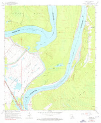
1965 Map of Lacour
USGS Topo · Published 1976About this map
The Mississippi River creates a dynamic border between Pointe Coupee and West Feliciana Parishes in this mid-1960s survey. The landscape is defined by the massive oxbow of Raccourci Old River, which isolates Raccourci Island from the mainland, creating a complex network of backwaters including Mondu Lake and Bundy Lake. This aquatic geography necessitated the heavy Levee system that protects the western settlements and the rail line of the Texas and Pacific Arkansas and Louisiana.
Find a feature on this map
31 named features on this map. Tap any name to fly to it.
Don’t see what you’re looking for? This feature index may not catch every label — zoom into the map to look around manually.
Map Details
Editions of this 1965 Lacour Map
4 editions found
Other maps of this area

1906 · Bayou Sara
USGS Topo · 1:125,000

1939 · St. Francisville
USGS Topo · 1:62,500

1939 · Fordoche
USGS Topo · 1:62,500

1941 · Batchelor
USGS Topo · 1:62,500

1953 · New Roads
USGS Topo · 1:24,000

1954 · Baton Rouge
USGS Topo · 1:250,000

1955 · Fordoche
USGS Topo · 1:62,500

1955 · Batchelor
USGS Topo · 1:62,500

1956 · Baton Rouge
USGS Topo · 1:250,000

1959 · Fordoche
USGS Topo · 1:62,500