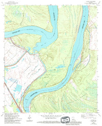
1965 Map of Lacour
USGS Topo · Published 1994About this map
Raccourci Island and the shifting channels of the Mississippi River dominate this landscape along the border of Pointe Coupee and West Feliciana Parishes. The map illustrates a complex hydraulic environment defined by the Morganza Floodway and the massive Levee system designed to manage the river's seasonal volatility. This mid-century survey documents the area's rural character, centered around the settlement of Lacour and essential local landmarks like Mt Zion Ch and Mount Olive Ch.
Find a feature on this map
32 named features on this map. Tap any name to fly to it.
Don’t see what you’re looking for? This feature index may not catch every label — zoom into the map to look around manually.
Map Details
Editions of this 1965 Lacour Map
4 editions found
Other maps of this area

1906 · Bayou Sara
USGS Topo · 1:125,000

1939 · St. Francisville
USGS Topo · 1:62,500

1939 · Fordoche
USGS Topo · 1:62,500

1941 · Batchelor
USGS Topo · 1:62,500

1953 · New Roads
USGS Topo · 1:24,000

1954 · Baton Rouge
USGS Topo · 1:250,000

1955 · Fordoche
USGS Topo · 1:62,500

1955 · Batchelor
USGS Topo · 1:62,500

1956 · Baton Rouge
USGS Topo · 1:250,000

1959 · Fordoche
USGS Topo · 1:62,500