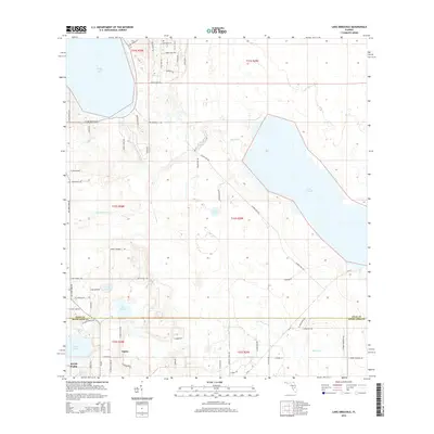
2015 Map of Lake Arbuckle
USGS Topo · Published 2015About this map
Avon Park sits at the southwestern edge of this landscape, where the developed residential grids of the city meet the expansive wetlands and lakes of the Central Florida interior. The geography is defined by a dense network of water bodies, from the large expanse of Reedy Lake in the northwest to the eponymous Lake Arbuckle sprawling across the eastern half. Smaller lakes like Lake Isabell, Lake David, and Lake Pythias dot the terrain, interspersed with citrus groves and undeveloped areas. The settlement of Alpine is visible just east of the main city limits. Local transit is characterized by a mix of established paved roads like CR-64 and more informal naming conventions such as School Bus Rd, Cow Pen Rd, and Indian Pipes Trl, reflecting the area's rural and residential character during this period.
Find a feature on this map
67 named features on this map. Tap any name to fly to it.
Don’t see what you’re looking for? This feature index may not catch every label — zoom into the map to look around manually.
Map Details
Editions of this 2015 Lake Arbuckle Map
This is the sole edition of this map. No revisions or reprints were ever made.
Other maps of this area

1952 · Lake Weohyakapka SE
USGS Topo · 1:24,000

1952 · Lake Arbuckle SW
USGS Topo · 1:24,000

1952 · Lake Arbuckle NE
USGS Topo · 1:24,000

1952 · Lake Arbuckle SE
USGS Topo · 1:24,000

1952 · Babson Park
USGS Topo · 1:24,000

1952 · Lake Arbuckle
USGS Topo · 1:24,000

1952 · Lake Weohyakapka
USGS Topo · 1:24,000

1953 · Frostproof
USGS Topo · 1:24,000

1953 · Avon Park
USGS Topo · 1:24,000

1956 · Fort Pierce
USGS Topo · 1:250,000