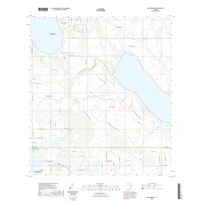
2021 Map of Lake Arbuckle
USGS Topo · Published 2021About this map
The Lake Wales Ridge dominates this Central Florida landscape, defining a high sandy spine that separates the wetlands of the Blue Jordan Swamp from the expansive waters of Reedy Lake and Lake Arbuckle. The settlement of Frostproof sits along the northern shore, while the small community of Alpine is located further south near the border of Avon Park. The map reveals a complex network of conservation lands and recreational paths within the Lake Wales Ridge State Forest, including the Arbuckle Tract Trl and various nature-named paths like Gopher Trl and Scrub Jay Trl. This interior region is defined by its numerous isolated water bodies, such as Lake Isabell, Lake David, and Lake Pythias, which are fed and drained by winding waterways like Livingston Cr and Bonnet Cr.
Find a feature on this map
73 named features on this map. Tap any name to fly to it.
Don’t see what you’re looking for? This feature index may not catch every label — zoom into the map to look around manually.
Map Details
Editions of this 2021 Lake Arbuckle Map
This is the sole edition of this map. No revisions or reprints were ever made.
Other maps of this area

1952 · Lake Weohyakapka SE
USGS Topo · 1:24,000

1952 · Lake Arbuckle SW
USGS Topo · 1:24,000

1952 · Lake Arbuckle NE
USGS Topo · 1:24,000

1952 · Lake Arbuckle SE
USGS Topo · 1:24,000

1952 · Babson Park
USGS Topo · 1:24,000

1952 · Lake Arbuckle
USGS Topo · 1:24,000

1952 · Lake Weohyakapka
USGS Topo · 1:24,000

1953 · Frostproof
USGS Topo · 1:24,000

1953 · Avon Park
USGS Topo · 1:24,000

1956 · Fort Pierce
USGS Topo · 1:250,000