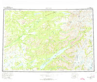
1958 Map of Lake Clark
USGS Topo · Published 1974About this map
Lake Clark dominates this mid-century landscape, acting as the central artery for a region defined by high peaks and sprawling river systems. The settlement at Port Alsworth and the nearby Tanalian Landing Area represent the era's critical dependence on bush aviation and water access. To the northeast, the Chigmit Mountains and the Aleutian Range form a formidable barrier, punctuated by the massive Iliamna Volcano and the deep crevasses of the Tuxedni Glacier.
Find a feature on this map
77 named features on this map. Tap any name to fly to it.
Don’t see what you’re looking for? This feature index may not catch every label — zoom into the map to look around manually.
Map Details
Editions of this 1958 Lake Clark Map
4 editions found

Other maps of this area

1944 · Kenai
USGS Topo · 1:250,000

1946 · Lake Clark
USGS Topo · 1:250,000

1949 · Tyonek
USGS Topo · 1:250,000

1950 · Kenai
USGS Topo · 1:250,000

1950 · Sleetmute
USGS Topo · 1:250,000

1950 · Taylor Mountains
USGS Topo · 1:250,000

1951 · Lake Clark
USGS Topo · 1:250,000

1951 · Taylor Mountains
USGS Topo · 1:250,000

1951 · Tyonek
USGS Topo · 1:250,000

1951 · Lime Hills
USGS Topo · 1:250,000