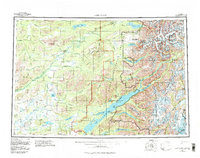
1958 Map of Lake Clark
USGS Topo · Published 1983About this map
Lake Clark and its massive surrounding wilderness are defined here by a network of glacial lakes and high peaks long before the area's modern management as a national park. The settlement of Port Alsworth sits on the eastern shore near a landing strip, serving as a primary point of access to the interior. The map documents the ancient Telaquana Trail winding through the north, connecting the Mulchatna River drainage with Old Village on the shores of Telaquana Lake. High alpine terrain is dominated by the Chigmit Mountains and the Neacola Mountains, with the prominent Iliamna Volcano standing near the eastern boundary. The intricate waterways, from the Chilikadrotna River to the Tazimina River, reveal a landscape shaped by glacial recession, as indicated by specific purple-screened patterns marking active ice movements in the high ranges.
Find a feature on this map
70 named features on this map. Tap any name to fly to it.
Don’t see what you’re looking for? This feature index may not catch every label — zoom into the map to look around manually.
Map Details
Editions of this 1958 Lake Clark Map
4 editions found

Other maps of this area

1944 · Kenai
USGS Topo · 1:250,000

1946 · Lake Clark
USGS Topo · 1:250,000

1949 · Tyonek
USGS Topo · 1:250,000

1950 · Kenai
USGS Topo · 1:250,000

1950 · Sleetmute
USGS Topo · 1:250,000

1950 · Taylor Mountains
USGS Topo · 1:250,000

1951 · Lake Clark
USGS Topo · 1:250,000

1951 · Taylor Mountains
USGS Topo · 1:250,000

1951 · Tyonek
USGS Topo · 1:250,000

1951 · Lime Hills
USGS Topo · 1:250,000