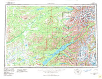
1958 Map of Lake Clark
USGS Topo · Published 1983About this map
Lake Clark dominates this mid-century topographic perspective of southwest Alaska, showing a landscape defined by glacial activity and a network of river systems. The settlement at Port Alsworth on the southern shore of the lake serves as a primary human landmark amidst the Chigmit Mountains and Neacola Mountains. The map traces the historical path of the Old Village Trail in the north, while features like Iliamna Volcano and the Tuxedni Glacier highlight the active tectonic and glacial forces shaping the eastern boundary near the Kenai Peninsula Borough. Numerous water bodies, including Twin Lakes, Telaquana Lake, and the Tazimina River with its upper and lower lakes, illustrate the complex hydrology of the Lake Clark National Park and Preserve. This record captures the region before extensive modern development, documenting the raw geography and isolated settlements characteristic of the 1950s interior.
Find a feature on this map
43 named features on this map. Tap any name to fly to it.
Don’t see what you’re looking for? This feature index may not catch every label — zoom into the map to look around manually.
Map Details
Editions of this 1958 Lake Clark Map
4 editions found

Other maps of this area

1944 · Kenai
USGS Topo · 1:250,000

1946 · Lake Clark
USGS Topo · 1:250,000

1949 · Tyonek
USGS Topo · 1:250,000

1950 · Kenai
USGS Topo · 1:250,000

1950 · Sleetmute
USGS Topo · 1:250,000

1950 · Taylor Mountains
USGS Topo · 1:250,000

1951 · Lake Clark
USGS Topo · 1:250,000

1951 · Taylor Mountains
USGS Topo · 1:250,000

1951 · Tyonek
USGS Topo · 1:250,000

1951 · Lime Hills
USGS Topo · 1:250,000