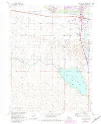
1970 Map of Lake Maloney
USGS Topo · Published 1983About this map
The South Platte River and its accompanying wetlands, including Beer Slough and Fremont Slough, dominate the northern landscape near the expanding borders of North Platte. This 1970s survey, updated in the early 1980s, documents a transition from agricultural land to urban and recreational development. To the south, the massive Lake Maloney serves as a centerpiece for local activity, featuring Scout Island, Goose Island, and Duck Island. The map shows a clear network of water management, with the Outlet Canal and a Powerhouse indicating the area's role in local infrastructure. Rural education and community life are grounded in the presence of several country schools, such as Miller Sch and Osgood Sch, while the North Platte Fish Hatchery and Clinch Airpark highlight the specialized land use during this period in Lincoln County.
Find a feature on this map
35 named features on this map. Tap any name to fly to it.
Don’t see what you’re looking for? This feature index may not catch every label — zoom into the map to look around manually.
Map Details
Editions of this 1970 Lake Maloney Map
2 editions found
Other maps of this area

1899 · North Platte
USGS Topo · 1:125,000

1902 · North Platte
USGS Topo · 1:125,000

1954 · McCook
USGS Topo · 1:250,000

1954 · North Platte
USGS Topo · 1:250,000

1956 · North Platte
USGS Topo · 1:250,000

1956 · Wellfleet NW
USGS Topo · 1:24,000

1957 · North Platte
USGS Topo · 1:250,000

1957 · McCook
USGS Topo · 1:250,000

1958 · McCook
USGS Topo · 1:250,000

1967 · North Platte
USGS Topo · 1:250,000