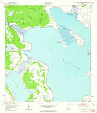
1952 Map of Lake Weohyakapka NE
USGS Topo · Published 1964About this map
Lake Kissimmee and Tiger Lake dominate this central Florida landscape, providing a detailed look at the intricate hydrologic systems of the early 1950s. The survey illustrates the natural path of the Kissimmee River before significant mid-century channelization projects altered its flow. Within these expansive waters, several large landmasses emerge, including the prominent Buster Island and the smaller Sturm Island and Rabbit Islands. The boundary between Osceola and Polk Counties is traced through these waterways, marking the intersection of local jurisdictions. This area is characterized by low-lying wetlands and complex shorelines, where Tiger Creek and Rosalie Creek contribute to the basin. The map serves as a primary source for understanding the pristine state of these lake ecosystems prior to extensive modern development and water management interventions.
Find a feature on this map
12 named features on this map. Tap any name to fly to it.
Don’t see what you’re looking for? This feature index may not catch every label — zoom into the map to look around manually.
Map Details
Editions of this 1952 Lake Weohyakapka NE Map
4 editions found
Other maps of this area

1952 · Lake Weohyakapka SE
USGS Topo · 1:24,000

1952 · Lake Weohyakapka NE
USGS Topo · 1:24,000

1952 · Hesperides
USGS Topo · 1:24,000

1952 · Lake Weohyakapka
USGS Topo · 1:24,000

1953 · Lake Marian NW
USGS Topo · 1:24,000

1953 · Cypress Lake
USGS Topo · 1:24,000

1953 · Lake Marian SW
USGS Topo · 1:24,000

1953 · Lake Hatchineha
USGS Topo · 1:24,000

1953 · Holopaw SW
USGS Topo · 1:24,000

1955 · Orlando
USGS Topo · 1:250,000