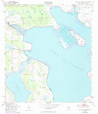
1952 Map of Lake Weohyakapka NE
USGS Topo · Published 1972About this map
Lake Kissimmee dominates this central Florida landscape, where the waters of the Kissimmee River enter the lake's western shore. The geography is defined by a network of islands and marshy transitions, with Buster Island and Sturm Island rising from the wetlands between the larger lake and Tiger Lake. Small tributaries like Tiger Creek and Rosalie Cr suggest the natural drainage patterns of the era before extensive modern water management.
Find a feature on this map
13 named features on this map. Tap any name to fly to it.
Don’t see what you’re looking for? This feature index may not catch every label — zoom into the map to look around manually.
Map Details
Editions of this 1952 Lake Weohyakapka NE Map
4 editions found
Other maps of this area

1952 · Lake Weohyakapka SE
USGS Topo · 1:24,000

1952 · Lake Weohyakapka NE
USGS Topo · 1:24,000

1952 · Hesperides
USGS Topo · 1:24,000

1952 · Lake Weohyakapka
USGS Topo · 1:24,000

1953 · Lake Marian NW
USGS Topo · 1:24,000

1953 · Cypress Lake
USGS Topo · 1:24,000

1953 · Lake Marian SW
USGS Topo · 1:24,000

1953 · Lake Hatchineha
USGS Topo · 1:24,000

1953 · Holopaw SW
USGS Topo · 1:24,000

1955 · Orlando
USGS Topo · 1:250,000