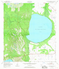
1952 Map of Lake Weohyakapka
USGS Topo · Published 1968About this map
Lake Weohyakapka dominates the eastern half of this Central Florida landscape, its broad waters held at an elevation of 62 feet. To the west, the terrain shifts into the dense vegetation of Tiger Creek Hammock and the intricate, seasonally wet expanses of the Blue Jordan Swamp. This 1952 survey shows a region largely defined by its natural hydrology, where Tiger Creek meanders through thickets and low-lying ground toward the larger lake. In the northern reaches, smaller water bodies like Lake Aurora appear, while the southern edge of the map captures a portion of Reedy Lake. The presence of established section lines and occasional unimproved roads suggests the early stages of land management and access in this part of Polk County, long before more intensive modern development altered the shoreline and surrounding wetlands.
Find a feature on this map
8 named features on this map. Tap any name to fly to it.
Don’t see what you’re looking for? This feature index may not catch every label — zoom into the map to look around manually.
Map Details
Editions of this 1952 Lake Weohyakapka Map
4 editions found
Other maps of this area

1952 · Lake Wales
USGS Topo · 1:24,000

1952 · Lake Weohyakapka SE
USGS Topo · 1:24,000

1952 · Lake Weohyakapka NE
USGS Topo · 1:24,000

1952 · Lake Arbuckle NE
USGS Topo · 1:24,000

1952 · Babson Park
USGS Topo · 1:24,000

1952 · Hesperides
USGS Topo · 1:24,000

1952 · Lake Arbuckle
USGS Topo · 1:24,000

1952 · Lake Weohyakapka
USGS Topo · 1:24,000

1953 · Frostproof
USGS Topo · 1:24,000

1956 · Fort Pierce
USGS Topo · 1:250,000