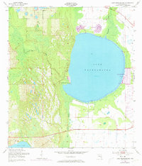
1952 Map of Lake Weohyakapka
USGS Topo · Published 1973About this map
Lake Weohyakapka dominates this Central Florida landscape, its vast blue surface surrounded by a network of wetlands and emerging mid-century residential developments. The 1970s revisions, indicated in purple, highlight the growth of planned communities like Indian Lake Estates on the eastern shore and the retirement enclaves of Nalcrest and Fedhaven to the north. These settlements represent a significant shift in land use, transforming formerly remote lakeside acreage into organized residential grids during Florida's post-war expansion.
Find a feature on this map
11 named features on this map. Tap any name to fly to it.
Don’t see what you’re looking for? This feature index may not catch every label — zoom into the map to look around manually.
Map Details
Editions of this 1952 Lake Weohyakapka Map
4 editions found
Other maps of this area

1952 · Lake Wales
USGS Topo · 1:24,000

1952 · Lake Weohyakapka SE
USGS Topo · 1:24,000

1952 · Lake Weohyakapka NE
USGS Topo · 1:24,000

1952 · Lake Arbuckle NE
USGS Topo · 1:24,000

1952 · Babson Park
USGS Topo · 1:24,000

1952 · Hesperides
USGS Topo · 1:24,000

1952 · Lake Arbuckle
USGS Topo · 1:24,000

1952 · Lake Weohyakapka
USGS Topo · 1:24,000

1953 · Frostproof
USGS Topo · 1:24,000

1956 · Fort Pierce
USGS Topo · 1:250,000