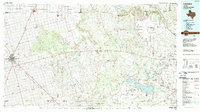
1986 Map of Lamesa
USGS Topo · Published 1989About this map
Lamesa serves as the primary hub of this West Texas landscape, which sits at the intersection of the High Plains and the rugged canyon breaks leading toward the Colorado River valley. The 1980s economy is clearly defined by the extensive energy infrastructure of the Good Oil Field, Ackerly Oil Field, and Diamond M Oil Field, illustrating the intensive industrial footprint on the land. To the east, the terrain drops from the Plains into a network of drainages like Holloway Canyon and Buck Canyon before reaching the waters of Lake J B Thomas.
Find a feature on this map
71 named features on this map. Tap any name to fly to it.
Don’t see what you’re looking for? This feature index may not catch every label — zoom into the map to look around manually.
Map Details
Editions of this 1986 Lamesa Map
2 editions found
Other maps of this area

1942 · Big Spring North
USGS Topo · 1:62,500

1950 · Cedar Bend
USGS Topo · 1:24,000

1951 · Ira SW
USGS Topo · 1:24,000

1951 · Ira
USGS Topo · 1:24,000

1951 · Dunn
USGS Topo · 1:24,000

1951 · Ira NW
USGS Topo · 1:24,000

1951 · Vincent
USGS Topo · 1:24,000

1952 · Cuthbert
USGS Topo · 1:24,000

1952 · Snyder
USGS Topo · 1:24,000

1952 · Ira NE
USGS Topo · 1:24,000