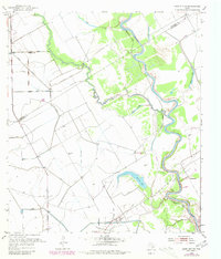
1952 Map of Lane City SE
USGS Topo · Published 1980About this map
The Colorado River snakes through the coastal plains along the border of Wharton and Matagorda counties in this mid-century topographic survey. The landscape is defined by an intricate network of irrigation and industry, dominated by the sprawling infrastructure of the North Markham Oil Field and numerous segments of Abandoned Canal. These relics of early water management systems, likely tied to rice farming or previous agricultural ventures, crisscross the terrain alongside natural drainage features like Blue Creek and Dry Creek.
Find a feature on this map
12 named features on this map. Tap any name to fly to it.
Don’t see what you’re looking for? This feature index may not catch every label — zoom into the map to look around manually.
Map Details
Editions of this 1952 Lane City SE Map
3 editions found
Other maps of this area

1950 · Houston
USGS Topo · 1:250,000

1951 · Bay City
USGS Topo · 1:250,000

1951 · Danevang
USGS Topo · 1:24,000

1952 · Lane City SE
USGS Topo · 1:24,000

1952 · Pledger
USGS Topo · 1:24,000

1952 · Bay City
USGS Topo · 1:24,000

1952 · Markham
USGS Topo · 1:24,000

1952 · Lane City
USGS Topo · 1:24,000

1952 · Van Vleck
USGS Topo · 1:24,000

1952 · Midfield
USGS Topo · 1:24,000