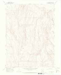
1969 Map of Lang Spring
USGS Topo · Published 1973About this map
Sevenmile Ridge dominates this portion of the high desert landscape in Moffat County, where a network of ephemeral drainages and vital water sources defined the area's utility in the late 1960s. The presence of Lang Spring and Spence Spring highlights the critical points of interest in an otherwise arid environment, serving as landmarks for local travel and grazing. These water features are connected by a sparse infrastructure of a Jeep Trail, illustrating how the terrain was navigated during this era of resource exploration. The map also records evidence of geological or industrial surveying with a noted Drill Hole in the northern sections. Topographic details trace the complex descent into valleys such as Yellow Cat Wash, Dugout Draw, and Lake Draw, providing a precise look at the drainage patterns flowing through the region's draws and gulches.
Find a feature on this map
10 named features on this map. Tap any name to fly to it.
Don’t see what you’re looking for? This feature index may not catch every label — zoom into the map to look around manually.
Map Details
Editions of this 1969 Lang Spring Map
3 editions found
Other maps of this area

1954 · Vernal
USGS Topo · 1:250,000

1958 · Vernal
USGS Topo · 1:250,000

1958 · Maybell
USGS Topo · 1:62,500

1960 · Vernal
USGS Topo · 1:250,000

1960 · Lone Mountain
USGS Topo · 1:62,500

1969 · Reservoir Draw
USGS Topo · 1:24,000

1969 · The Nipple
USGS Topo · 1:24,000

1969 · Sheepherder Springs
USGS Topo · 1:24,000

1969 · Coffeepot Spring
USGS Topo · 1:24,000

1969 · Powder Wash
USGS Topo · 1:24,000