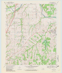
1970 Map of Langston
USGS Topo · Published 1982About this map
Langston University and the historic community of Langston anchor the eastern edge of this Oklahoma survey, situated north of the meandering Cimarron River. The landscape reveals a transition between rural agriculture and industrial development during the early 1970s, evidenced by the expansive Guthrie Gas and Oil Field and numerous active oil wells. An important infrastructure project is documented near the university, with the Langston Dam spillway noted as under construction, signaling the impending creation of a reservoir.
Find a feature on this map
32 named features on this map. Tap any name to fly to it.
Don’t see what you’re looking for? This feature index may not catch every label — zoom into the map to look around manually.
Map Details
Editions of this 1970 Langston Map
3 editions found
Other maps of this area

1892 · Guthrie
USGS Topo · 1:62,500

1893 · Mulhall
USGS Topo · 1:62,500

1893 · Stillwater
USGS Topo · 1:62,500

1909 · Perkins
USGS Topo · 1:62,500

1954 · Oklahoma City
USGS Topo · 1:250,000

1955 · Enid
USGS Topo · 1:250,000

1957 · Oklahoma City
USGS Topo · 1:250,000

1958 · Enid
USGS Topo · 1:250,000

1963 · Oklahoma City
USGS Topo · 1:250,000
1967 · Stillwater SW
USGS Topo · 1:24,000