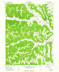
1961 Map of Latham
USGS Topo · Published 1963About this map
Sunfish Creek meanders through this portion of the Virginia Military District, defining a landscape of sharp ridges and narrow hollows. In the early 1960s, the rural character of Pike County is evident in the scattered settlements of Latham and Idaho, where local life centered around small country institutions like the Township Sch and the Parker Sch. The terrain is heavily marked by family-named landmarks and historical burial grounds, including the Gardner Cem, Arkoe Cem, and Smith Hill Ch Cem, which offer significant data points for genealogical research.
Find a feature on this map
65 named features on this map. Tap any name to fly to it.
Don’t see what you’re looking for? This feature index may not catch every label — zoom into the map to look around manually.
Map Details
Editions of this 1961 Latham Map
4 editions found
Other maps of this area

1915 · Bainbridge
USGS Topo · 1:48,000

1915 · Otway
USGS Topo · 1:62,500

1915 · Piketon
USGS Topo · 1:62,500

1916 · Peebles
USGS Topo · 1:62,500

1917 · Bainbridge
USGS Topo · 1:62,500

1917 · Piketon
USGS Topo · 1:62,500

1917 · Otway
USGS Topo · 1:62,500

1918 · Peebles
USGS Topo · 1:62,500

1944 · Piketon
USGS Topo · 1:62,500

1947 · Columbus
USGS Topo · 1:250,000