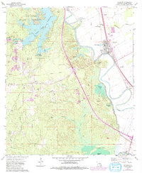
1972 Map of Lecompte
USGS Topo · Published 1992About this map
The town of Lecompte and the surrounding agricultural bottomlands of Rapides Parish define this 1970s landscape, later updated to reflect modern shifts. The area is dominated by the winding course of Bayou Boeuf and the significant water management infrastructure of the Bayou Boeuf Cocodrie Diversion Channel. To the west, the managed timber of Alexander State Forest surrounds the large Indian Creek Reservoir and the Indian Creek State Fish Hatchery. Genealogists will find a high concentration of burial sites and rural congregations, including Wilmer Memorial Cem, Mt Lebanon Ch, and Martin Springs Cem. The presence of an Old RR Grade and numerous Gravel Pits suggests an economy rooted in both the transport of timber and the extraction of local resources during this era of development.
Find a feature on this map
52 named features on this map. Tap any name to fly to it.
Don’t see what you’re looking for? This feature index may not catch every label — zoom into the map to look around manually.
Map Details
Editions of this 1972 Lecompte Map
3 editions found
Other maps of this area

1935 · Turkey Creek
USGS Topo · 1:62,500

1935 · Lecompte
USGS Topo · 1:62,500

1942 · Oakdale
USGS Topo · 1:62,500

1949 · Glenmora
USGS Topo · 1:31,680

1949 · Turkey Creek
USGS Topo · 1:62,500

1952 · Lake Charles
USGS Topo · 1:250,000

1953 · Alexandria
USGS Topo · 1:250,000

1954 · Lake Charles
USGS Topo · 1:250,000

1955 · Alexandria
USGS Topo · 1:250,000

1956 · Forest Hill
USGS Topo · 1:62,500