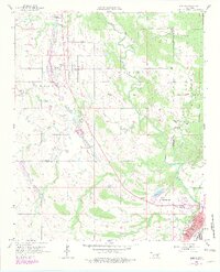
1957 Map of Lehigh
USGS Topo · Published 1979About this map
Lehigh and Phillips sit at the center of an industrial and agricultural landscape transitioning in the late 1950s, bounded by the Coal County and Atoka County line. The terrain is marked by significant Strip Mine operations, particularly near Hickory Hill, reflecting the region's extractive economy. Water dominates the eastern half of the map, where the Muddy Boggy Creek winds toward Atoka Lake.
Find a feature on this map
31 named features on this map. Tap any name to fly to it.
Don’t see what you’re looking for? This feature index may not catch every label — zoom into the map to look around manually.
Map Details
Editions of this 1957 Lehigh Map
4 editions found
Other maps of this area

1896 · Coalgate
USGS Topo · 1:125,000

1899 · Coalgate
USGS Topo · 1:125,000

1899 · Atoka
USGS Topo · 1:125,000

1900 · Atoka
USGS Topo · 1:125,000

1900 · Coalgate
USGS Topo · 1:125,000

1956 · Stringtown
USGS Topo · 1:24,000

1957 · Coalgate
USGS Topo · 1:24,000

1957 · Lehigh
USGS Topo · 1:24,000

1957 · Coalgate SE
USGS Topo · 1:24,000

1957 · Bruno
USGS Topo · 1:24,000